
A strong to very strong El Niño pattern is expected to persist into early next year, potentially steering storm tracks toward the southern United States and increasing moisture levels across the Southwest, according to a report from KOB 4.
The National Oceanic and Atmospheric Administration (NOAA) currently favors a wetter-than-average winter for the region. While this increase in precipitation provides a reprieve from recent dry spells, it also introduces specific hydrological risks for New Mexico residents.
Weeks of recent flooding have already begun to reverse severe drought conditions in parts of the state. This shift has replenished soil moisture, creating a scenario where the ground is primed to absorb—or potentially be overwhelmed by—incoming winter weather.
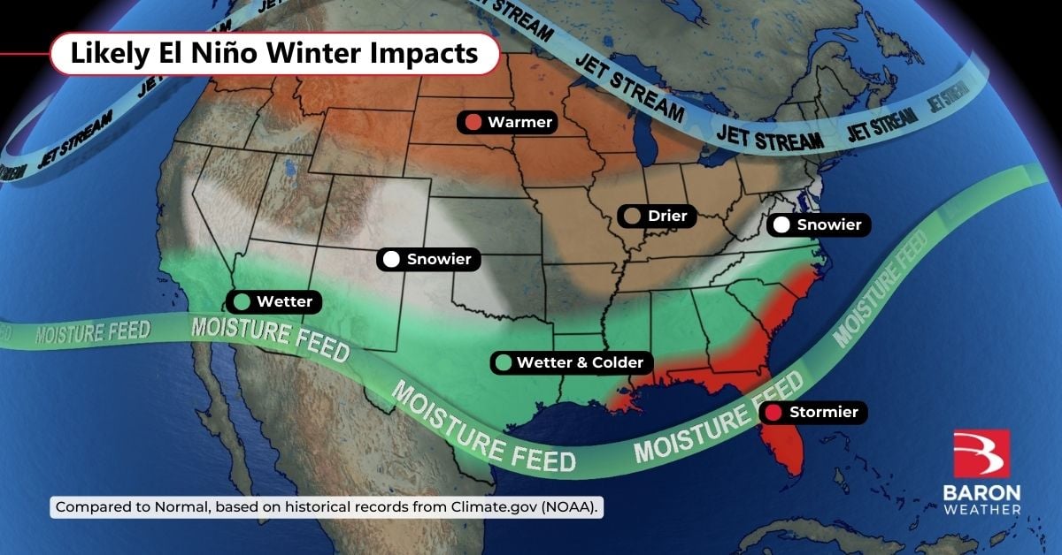
The primary concern for local officials and residents isn’t just the rain falling this winter, but how that moisture interacts with the spring thaw. If the current soil moisture remains high through the winter months, much of the melting snowpack could turn into immediate runoff rather than soaking into the earth.
The transition from a wet winter to a spring melt is a delicate balance. A gradual thaw often serves as a benefit, providing months of steady, valuable water for the region’s ecosystems and agricultural needs. However, the danger rises if the snow melts too quickly or if heavy spring rains fall on top of an existing snowpack.
While the current atmospheric setup does not guarantee a massive mountain snowpack, the increased moisture availability keeps the possibility of significant runoff on the table. This makes the upcoming season more complex than a typical year for water management and flood preparedness.
New Mexico has experienced the volatility of El Niño-driven weather patterns before. History shows that these cycles can swing from drought to significant hydrological stress quite rapidly.
In 1941, a major flooding event hit the Rio Grande during an El Niño period. Decades later, the state faced different but equally pressing challenges; following the El Niño winter of 1973, heavy snowmelt put significant strain on Albuquerque’s levee systems.
Modern infrastructure has changed the landscape of flood management, but the underlying physics of snowmelt and runoff remain a constant variable. The actual impact on communities will depend heavily on the specific volume of the snowpack and the speed at which temperatures rise in the spring.
For more information on regional weather patterns and official forecasts, residents can monitor updates from the National Oceanic and Atmospheric Administration.
Related reading

Nashville Stampede Makes History as First Back-to-Back PBR Teams Champions
Nashville Stampede makes history at T-Mobile Arena The Nashville Stampede became the first team in PBR Teams history...

Columbia School of the Arts MFA Visual Arts and Sound Art Open Studios
Columbia University hosts MFA open studios The Class of 2027 from the Columbia University School of the Arts...

Community Members Oppose Parole for Kimberly Rock Murderer Robert Jewett
Robert Jewett, the man convicted of the 1990 murder of 17-year-old Kimberly Rock, is seeking parole during a...

Washington Spirit Defeat Portland Thorns FC 4-1
The Washington Spirit defeated Portland Thorns FC 4-1 at Audi Field on Sunday afternoon to secure a dominant...