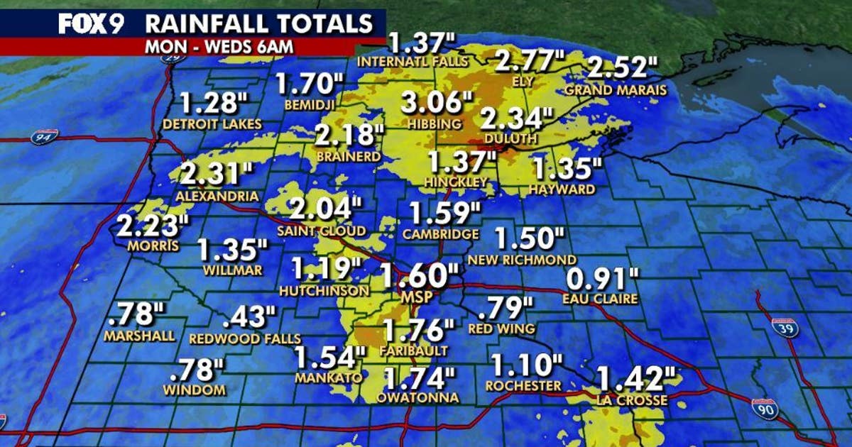
Hibbing has taken the heaviest soaking in Minnesota this week, accumulating 3.06 inches of rain as of 6 a.m. Wednesday, according to FOX 9 meteorologists. The northern city leads a statewide deluge that has pushed several regions past the 2-inch mark since Monday, offering a stark contrast to the drier-than-normal conditions that defined 2026 up until this week.
FOX 9 reported that after a year marked by below-average precipitation across much of the state, Minnesota is finally catching up on rainfall as November begins. The soaking that started Monday and continued through Wednesday has drenched the northern and specifically northeast regions most severely, with totals climbing well beyond what the Twin Cities metro has seen during the same three-day period.
This matters now because 2026 has been running drier than normal across Minnesota. When a single community like Hibbing picks up more than three inches in less than 72 hours, the state is clearly making up ground on rainfall it missed earlier in the year, with the northern tier absorbing the heaviest share of that catch-up.
Northern Minnesota Leads the Statewide Rainfall Tally
The northeast corner of the state has borne the brunt of this storm system. Ely follows Hibbing with 2.77 inches, while Grand Marais has recorded 2.52 inches and Duluth 2.34 inches. These four cities alone represent the heaviest concentrations of rainfall, each surpassing two and a half inches in less than three days of persistent precipitation.
Moving into the central and northern portions of Minnesota, the totals remain impressive. Alexandria has tallied 2.31 inches, Morris 2.23 inches, Brainerd 2.18 inches, and St. Cloud 2.04 inches. Each of these communities has exceeded the 2-inch rainfall mark—a measure showing how heavy this storm was for drought-stricken areas.
The geographic pattern is unmistakable: the further north and east you travel, the wetter it has been. This uneven distribution means that while the northeast deals with the heaviest soaking, the central lakes region is also seeing significant accumulation, with every listed community from Alexandria to St. Cloud exceeding two inches.
Twin Cities Metro Sees Significant but Lighter Totals
Closer to the Twin Cities region, the rainfall totals tell a noticeably different story. Prior Lake leads the metro area with 2.22 inches, followed by Lakeville at 2.10 inches and Waconia at 2.03 inches. The outer suburbs continue with Hugo at 1.94 inches, Eagan at 1.89 inches, Victoria at 1.88 inches, Maple Grove at 1.86 inches, and Maple Plain at 1.80 inches.
The contrast between north and south becomes striking when comparing the two largest cities to the state leaders. Minneapolis has accumulated 1.50 inches, while St. Paul has seen just 1.16 inches during the same Monday-to-Wednesday window. That means Hibbing received nearly three times as much rain as St. Paul, highlighting the uneven distribution of this storm system across Minnesota’s geography.
For metro residents, the 1-to-2 inch range still represents significant rainfall after a dry year, but it falls well short of the soaking experienced in the northern regions. Within the metro itself, the gradient is noticeable. Prior Lake’s 2.22 inches stands more than a full inch above St. Paul’s 1.16 inches, showing how localized these rain totals can be even within the same metropolitan area. The suburban ring has generally fared wetter than the urban core, with eight different communities topping 1.80 inches.
Rain Continues Wednesday Before Dry Weekend Arrives
The soaking is not finished yet. FOX 9 meteorologists expect rain showers to continue throughout Wednesday across much of the state, with temperatures climbing only a few degrees into the mid-50s before staying fairly steady through midday and into the afternoon. Rain will linger this evening and push into parts of the overnight period, keeping surfaces wet through Wednesday night.
However, the forecast shifts dramatically by the weekend. Saturday and Sunday look dry with more sunshine than clouds, offering a welcome reprieve from the midweek deluge. Saturday morning is expected to be the coolest of the weekend, arriving just in time for Minnesota’s deer opener. Afternoon temperatures should climb above average starting this weekend and continue into early next week, giving the state a dry window after the wet start to November.
Looking further ahead, the above-average temperatures are expected to persist into early next week, extending the dry pattern beyond just the weekend. This prolonged break from rain gives the state a chance to absorb the moisture from the midweek soaking without additional precipitation interfering. The shift from soaking rain to dry sunshine arrives at a critical moment, with Saturday’s cool morning timed for the deer opener and warmer, drier conditions settling in for the days that follow.
Related reading

Nathan Spencer Pleads Guilty to Leaving Scene of Jefferson City Crash
Nathan Spencer pleaded guilty on Nov. 4, 2026, to a single misdemeanor charge of leaving the scene of...

Mississippi Senate Race: Scott Colom and Cindy Hyde-Smith in Tight Battleground Contest
How Mississippi Became an Unlikely Senate Battleground As of Wednesday afternoon, Democrat Scott Colom was just a few...
3M Agrees to $7.35 Billion Settlement Over PFAS Forever Chemical Personal Injury Claims
3M has agreed to pay $7.35 billion to resolve personal injury claims brought by more than 100,000 plaintiffs...

Metro Detroit voters approve zoo, museum millages and police/fire funding; reject Flint name change
Metro Detroit voters on Tuesday approved a sweeping slate of tax measures that will keep the Detroit Zoo...