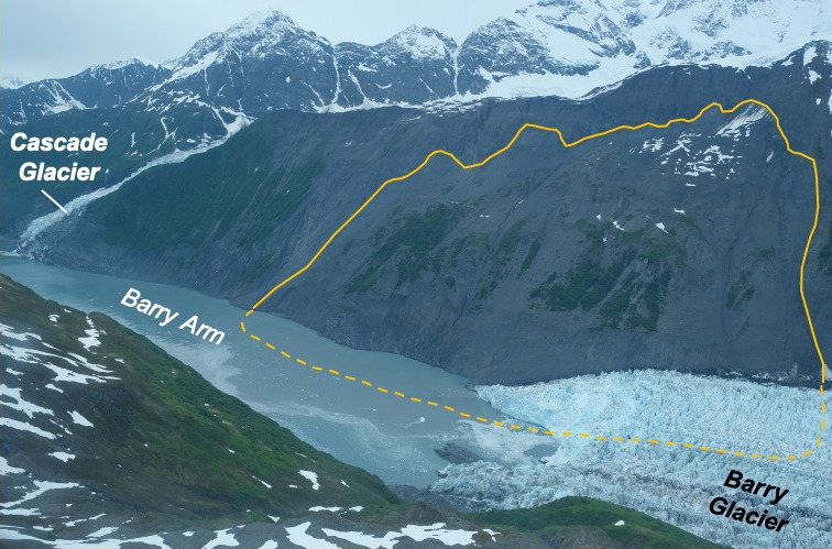
A 481-meter-high landslide-tsunami occurred in a cruise ship–frequented Alaska fjord, and the rock slope that birthed it is still moving, Nature reported this month.
The event, documented in Science by Dan Shugar and colleagues, rewrote the hazard playbook for Prince William Sound. Satellite interferometry had already flagged the Barry Arm slope as a crisis in slow motion; the 2024 Pedersen Lagoon slide confirmed that the region’s deglaciating walls can fail without an earthquake trigger.
Glaciers buttress steep rock slopes. When they thin, the lateral support vanishes and the rock mass expands, fractures, and creeps downslope. Research in Geomorphology showed that the 2015 landslide and tsunami in Taan Fiord occurred after Tyndall Glacier retreated. The same paraglacial mechanism drives the Barry Arm instability, where the glacier has thinned.
“Permafrost controls the displacement rates of large unstable rock-slopes in subarctic environments,”
Irena Penna and co-authors wrote in Global and Planetary Change (2023)
Warming permafrost deepens the active layer, allowing water to penetrate fracture networks and lubricate failure planes. Thermomechanical modeling by Hugentobler et al. demonstrated that a retreating temperate glacier alters the stress field of a rock slope.
Interferometric SAR from Sentinel-1 now maps millimeter-scale motion across thousands of square kilometers. Kim et al. mapped landslides and subsidence in rapidly deglaciating terrain, including Glacier Bay National Park and Preserve, between 2018 and 2020. The USGS Open-File Report 2023–1099 applied satellite interferometry landslide detection and preliminary tsunamigenic plausibility assessment to Prince William Sound, southcentral Alaska.
Seismic networks complement the radar. Ezgi Karasözen’s team built a prototype landslide-triggered tsunami monitoring system for Prince William Sound; it captured the 2024 Surprise Inlet landslides.
Prince William Sound opens off the Gulf of Alaska on the south coast of Alaska, east of the Kenai Peninsula. Its largest port, Valdez, marks the southern terminus of the Trans-Alaska Pipeline System. The sound was entered by James Cook in 1778 and later named for Prince William Henry.
On March 27, 1964, the magnitude 9.2 Good Friday earthquake generated a tectonic tsunami and about 20 local landslide tsunamis; a 27-foot wave destroyed the village of Chenega, killing 23 of 68 residents, and an underwater landslide at Port Valdez killed 32 people. On March 24, 1989, the Exxon Valdez ran aground on Bligh Reef, spilling oil that eventually impacted 1,300 miles of coastline.
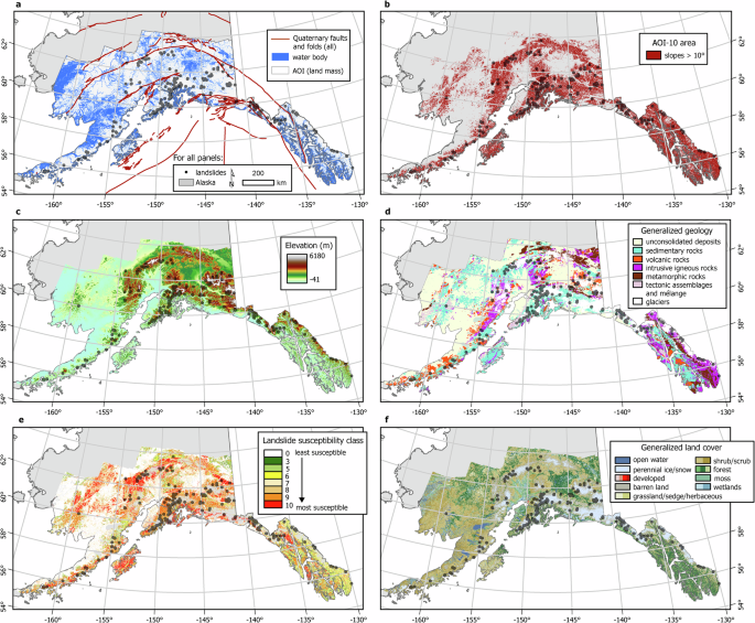
Alaska’s mean annual temperature has risen since 1957, and equilibrium-line altitudes on its glaciers change. The Alaska Division of Geological & Geophysical Surveys’ 2025 susceptibility map at 1:3,750,000 scale shows deep-seated landslide potential across Alaska — terrain threaded by cruise routes, fishing fleets, and coastal communities.
Related reading

Four Anchorage Men Diagnosed With Clade Ib Mpox, No Travel History, Raising Local Transmission Concerns
Four Anchorage men have been diagnosed with mpox despite reporting no travel outside Alaska, raising the prospect of...

USDA Meat Animal Research Center Posts Farm Hand Job at $18/Hour
A 34,000-acre research facility in the heart of Nebraska is hiring a farm hand, offering $18 an hour...

Thunder, Pelicans Play NBA Cup Game With Heavy Injury Lists
The Oklahoma City Thunder host the New Orleans Pelicans Friday night in an NBA Cup group-stage matchup where...
PA Humanities Honors 180 Window Keepers From 65 Pennsylvania Counties
"Democracy is a labor of love and of loving," Yolanda Wisher told the room at the Civic Club...