
A powerful Bering Sea storm is driving hurricane-force wind gusts, heavy snowfall, and coastal flooding toward Western Alaska while setting up a prolonged wintry mix for Southcentral, according to forecasts tracked by the National Weather Service.
The National Weather Service reports that the low-pressure system will reach its strongest intensity of 945 to 955 millibars as it tracks east between St. Paul and St. Lawrence islands. Communities along the Kuskokwim Delta coast and the southern Seward Peninsula face water levels projected to rise 4 to 7 feet above the normal high tide line, bringing severe coastal erosion risks.
The National Weather Service reports that storm warnings cover Bering Sea and Aleutian waters, alongside high wind warnings for Adak, Atka, and the Pribilof Islands. Southwest winds in those areas are expected to reach 45 to 60 mph, with gusts climbing as high as 80 mph.
“Travel will be difficult,” the National Weather Service warned, noting that high winds could move loose debris, damage property, and trigger widespread power outages.
While Western Alaska braces for coastal flooding, Southcentral is dealing with its longest stretch of subfreezing temperatures so far this season. Anchorage temperatures have remained below freezing since Saturday.
Freezing fog gripped the region before an atmospheric river began sliding east, bringing a winter weather advisory for mixed precipitation from Wednesday morning through Friday afternoon, Alaska’s News Source reported. Forecasters expect a glaze of ice up to a few hundredths of an inch.
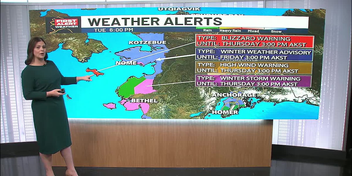
Winds will build across Southcentral from Wednesday evening through Thursday. Strong gusts up to 60 mph are possible along the Anchorage Hillside, while the Anchorage Bowl expects winds between 30 and 45 mph.
Interior Alaska continues to experience unusual warmth for November. Fairbanks has yet to record its first subzero low of the season, approaching the record for the latest first zero or colder temperature ever recorded, which stands at November 22.
At the same time, a high wind warning remains in effect for the Alaska Range, where southerly winds could gust up to 80 mph. These winds will push warmer air into the Interior, allowing temperatures to break above freezing before cooling off toward the end of the week.
Very strong winds could cause extensive damage to power lines.
Monday to 6 a.m. Tuesday, Alaska time.
Adak’s winds would peak near 3 a.m. Tuesday.
Flooding concerns remain for areas of the Kenai, with heavy rain set to build into coastal areas of Southcentral. If you live along southern parts of the Kenai, be prepared for flooding from excessive rainfall and snowfall melt.
Keep reading

Two Indianapolis Men Arrested in Jackson County Scam Targeting 73-Year-Old Woman
Two men from Indianapolis are facing felony fraud and theft charges following a monthslong investigation into a scam...
Winter Garden aGlow Returns to Idaho Botanical Garden With 900,000 Lights and New Expansion
The Idaho Botanical Garden is preparing to illuminate its grounds with nearly 900,000 lights as the annual Winter...

US Pacific Command Deputy Rowell Keynotes Honolulu International Forum
The Pacific Forum is convening the Honolulu International Forum to address the shifting security situation in the Indo-Pacific,...

Synovus Bank Amphitheater: Partial Policies, 3 Events Noted for 2026-2027
The Synovus Bank Amphitheater at Chastain Park, located at 4469 Stella Drive Northwest in Atlanta, maintains distinct operational...