
Calgary police recorded 178 collisions between midnight and 4 p.m. Wednesday as a Colorado low dumped heavy, wet snow across southern Alberta.
The storm began late Tuesday and intensified overnight. Environment and Climate Change Canada had warned of 15 to 20 centimetres for Calgary, with the city on the lower end of that range, and an additional five to 10 centimetres through Wednesday before tapering off in the evening. By afternoon, the agency lifted its yellow snowfall warning for the city, though total accumulations of 15 to 30 centimetres were still expected across the region.
A slow-moving Colorado low continued to bring winter weather across the southern Prairies on Wednesday, Nov. 18, 2026. The system stalled overnight before moving eastward into Saskatchewan Wednesday morning, delaying rain in some communities.
Additional snowfall of five to 10 centimetres was forecast for Wednesday, with a final accumulation of 15 to 30 centimetres expected before the weather system tapered off Wednesday evening. More favoured locations such as the foothills, the Cypress Hills, and rural areas of southern Alberta near Brooks, Medicine Hat, and Lethbridge may see snowfall amounts near 25 centimetres.

Environment Canada also issued a special weather statement for areas north of Calgary, including Red Deer, Penhold, Olds, Innisfail, and areas east of Red Deer including Stettler, Bashaw, and Castor, where accumulating snow began Tuesday afternoon or evening, bringing five to 10 centimetres before tapering off later Wednesday.
A snowfall warning was issued for Kananaskis Country and Bow Valley near Canmore and Exshaw, with snowfall amounts of 15 to 25 centimetres expected. In southwest Saskatchewan, a yellow snowfall warning remained in effect for the Cypress Hills region, including Maple Creek, Eastend, and the Cypress Hills, with a forecast of 10 to 15 centimetres. Environment Canada updated this warning at 10:04 a.m. Wednesday, maintaining a moderate impact level and high forecast confidence.
Of the 178 crashes, 17 involved minor injuries and 29 were hit-and-runs. The most serious collision occurred just before 7 a.m. on southbound Deerfoot Trail near Cranston Avenue, where a four-vehicle crash sent one person to hospital with life-altering injuries. Earlier, police responded to more than 60 collisions between midnight and 8 a.m., including 16 with injuries and eight hit-and-runs. None of the other collisions were as serious.
Snow Event Update (November 17, 2026) Environment Canada has issued a snowfall warning with 15 cm to 20 cm of snowfall expected by tomorrow afternoon. There may be impact to the morning commute. Before and during snowfall our crews work around the clock, preparing equipment and… pic.twitter.com/zpJRDfJAGT
Snow detours affect transit routes and airport operations
Calgary Transit listed more than three dozen routes on snow detours due to slippery road conditions and advised passengers that some routes may be behind schedule or required to detour. At the Calgary International Airport, crews worked around the clock clearing runways, taxiways and aprons, but the wet snow complicated operations.
Outside the city, Alberta RCMP warned that highways throughout southern Alberta were in “extremely poor condition” due to snow and icy surfaces. Officers responded to multiple collisions across the region, with vehicles of all types becoming stuck in ditches and on roadways.
Westbound Highway 1 between Highway 56 and Gleichen was closed after multiple jackknifed semi-trucks blocked the road; travellers were directed to detour via northbound Highway 56 and eastbound Highway 561. Highway 56 and junction Highway 901 near Gleichen was closed due to multiple jackknifed semis.
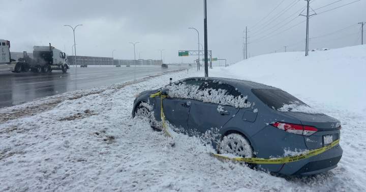
“If travel is necessary, motorists should be prepared for hazardous driving conditions and possible delays,” the RCMP advised, urging drivers to slow down, increase following distance and ensure vehicles were properly equipped for winter conditions.
Those heading into Alberta could consult Alberta 511 for updated road conditions and possible closures.
❄️ All snow detours are currently active, to help us avoid places where buses may get stuck. Wondering if your route has a snow detour? View them all at https://t.co/Lj6WJ6ZSYB
Heavy snow causes power outages and school closures in Lethbridge
In Lethbridge, heavy snow downed trees and branches, damaging vehicles and blocking streets. As of 11:45 a.m., several areas in Lethbridge County were experiencing power outages. The Westwind School Division, which operates 13 community schools in towns including Cardston, Magrath and Raymond, cancelled classes for the day.
The University of Lethbridge and Lethbridge Polytechnic also closed, with the polytechnic declaring a mandatory campus evacuation effective at noon. Residents of Lethbridge woke to a winter wonderland on Wednesday morning, though the wintry scene came at a slippery cost for commuters trying to move about. The RCMP advised drivers in southern Alberta against any non-essential travel.
City crews began pre-treatment Tuesday
City of Calgary crews started preparing roads Tuesday, applying anti-icing agents on bridges, hills and intersections. Roughly 100 snowplows began clearing priority routes Wednesday morning. The municipality maintains about 750 kilometres of prioritized pathways and clears roughly 10 per cent of the city’s sidewalks; private property owners are responsible for the remainder within 24 hours of snowfall ending.
Research note: chinook decline
Amid the storm coverage, CBC highlighted new University of Calgary research suggesting chinook winds are declining in frequency and strength across southeastern Alberta.
“Bear in mind your stopping distances,” Calgary Police Service Staff Sgt. Andy Woodward told reporters. “Once you do that, if you do slide, then turn your wheel towards the curb.”
“Prepare for quickly changing and deteriorating travel conditions,” Environment and Climate Change Canada said. “If driving, turn on your lights, slow down and maintain a safe following distance,” the agency advised. CTV Your Morning’s Meteorologist Kelsey McEwen explained how much snow areas of southern Alberta and Saskatchewan can expect in the next 24 hours, noting the winter weather is moving up from Montana.
As the system progresses into Saskatchewan, it becomes the next big weather maker across parts of Ontario and Quebec through the weekend. Medicine Hat could see five to 10 centimetres into Thursday, and totals up to 20 centimetres are possible around Cypress Hills.
Keep reading

Louisiana Rural Education Association Convenes Summit Demanding Intentional Rural Investment
The Louisiana Rural Education Association convened its annual summit on Nov. 13 at LSU’s Huey P. Long Field...

No. 8 Doddridge County Travels to No. 1 Frankfort for Quarterfinal Rematch of Semifinal
Doddridge County's Bulldogs are back where they expect to be in November, but the road ahead runs through...

San Antonio Zoo Welcomes African Lion Tatu to Big Cat Valley Under Species Survival Plan
San Antonio Zoo welcomed a new male African lion named Tatu to Big Cat Valley on Wednesday, Nov....

Iowa Vape Directory Limits Legal Products to 361, Retailers Project Major Losses
Iowa's new vapor products directory took effect Monday, Nov. 16, cutting the number of e-cigarettes retailers can legally...