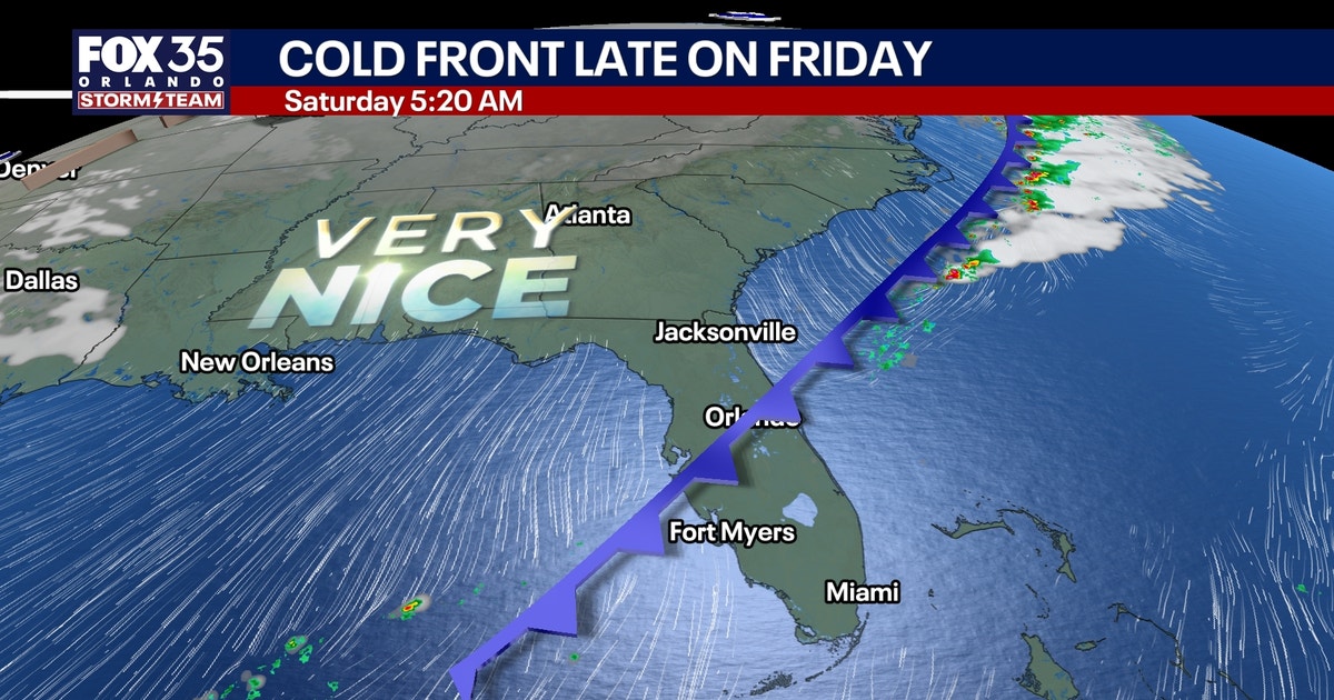
Central Florida is finally catching a break from the relentless heat as a cold front pushes through the region this weekend, bringing a subtle but welcome shift in the humidity. While residents have been contending with persistent warmth, the FOX 35 Storm Team reports that the incoming front will lower temperatures and usher in more comfortable, drier air starting Saturday.
For those living near the St. Johns River, however, the cooling weather offers little immediate relief. A significant volume of water from Monday’s historic flooding is currently moving north through the river basin. According to data tracked by the FOX 35 Storm Team, several locations along the river are approaching major flood stage, meaning that despite the pleasant weekend forecast, the local infrastructure remains under intense pressure.
Flood Warnings Persist Amidst Temperature Dip
The immediate concern for the river communities remains the rising water levels. River flood warnings are currently in effect for Cocoa, Geneva, Sanford, DeLand, and Astor. Meteorologists emphasize that water levels are expected to continue rising over the next several days, indicating that the situation in these basins will likely worsen before any meaningful improvement takes hold.

This hydrological reality stands in stark contrast to the meteorological forecast for the rest of the region. Friday will remain very warm and humid with highs reaching the mid-80s. While some isolated showers are possible along the Treasure Coast and northern Central Florida, most areas are expected to stay dry, with rainfall totals generally remaining under a quarter-inch.
| Location | Status |
|---|---|
| Cocoa | Flood Warning Active |
| Geneva | Flood Warning Active |
| Sanford | Flood Warning Active |
| DeLand | Flood Warning Active |
| Astor | Flood Warning Active |
Weekend Forecast and Longer-Term Patterns
By Saturday, the cold front will complete its passage, effectively sweeping away the heavy humidity that has defined the week. Highs will hover in the low to mid-80s, but the arrival of northerly winds will make the air feel noticeably more manageable. Sunday is shaping up to be the standout day of the weekend, with mostly sunny skies and temperatures settling into a pleasant range between the upper 70s and lower 80s.
Looking into next week, the pattern remains cooler. Morning lows are expected to drop into the upper 50s for areas northwest of the I-4 corridor, while the rest of the region will see temperatures in the 60s. Monday and Tuesday appear largely dry, though a 10% to 20% chance of rain persists through Wednesday. Meteorologists are monitoring a potential disturbance that could increase rain chances to approximately 30% by Thursday, though severe weather is not currently anticipated.
Beach and Boating Hazards Remain Elevated
While the land-based weather is improving, the Atlantic coastline tells a different story. A high rip current risk remains in effect for all Central Florida beaches, stretching through the weekend and likely into early next week. This hazard is driven by swells generated by non-tropical low pressure situated east of the Bahamas.
The physical state of the ocean reflects this energy, with seas currently running between 3 and 5 feet. These conditions are expected to build to 4 to 6 feet through the weekend, particularly in offshore waters. While the non-tropical low is not expected to develop into a tropical or subtropical system that would threaten Florida, the surf conditions alone serve as a significant deterrent for recreational boaters and swimmers.
The contrast between the cooling inland forecast and the hazardous coastal conditions highlights the complexity of the current weather pattern. Residents are advised to monitor official updates regarding the St. Johns River, as the lag time between rainfall and peak flood crests means the most dangerous phase for those communities is still ahead.
Keep reading

MTA Urges Congress for Reliable Funding and Tariff Relief
The MTA’s Post-Election Wishlist for Congress Following the results of Tuesday’s national election, which handed Democrats a firm...

Deb Haaland elected governor as Colorado flooding causes detours
New Mexico is entering a new chapter of governance following this week’s election results, which solidified a Democratic...

Darren Moore selects England men’s under-20s squad for November
The England men’s under-20s squad has been confirmed for upcoming Elite League fixtures against Czechia and Portugal, with...

Man Swept Into Lake Superior at Presque Isle Park Black Rocks
Marquette Police Close Presque Isle Park Following Lake Superior Incident The Marquette Police Department has shuttered Presque Isle...