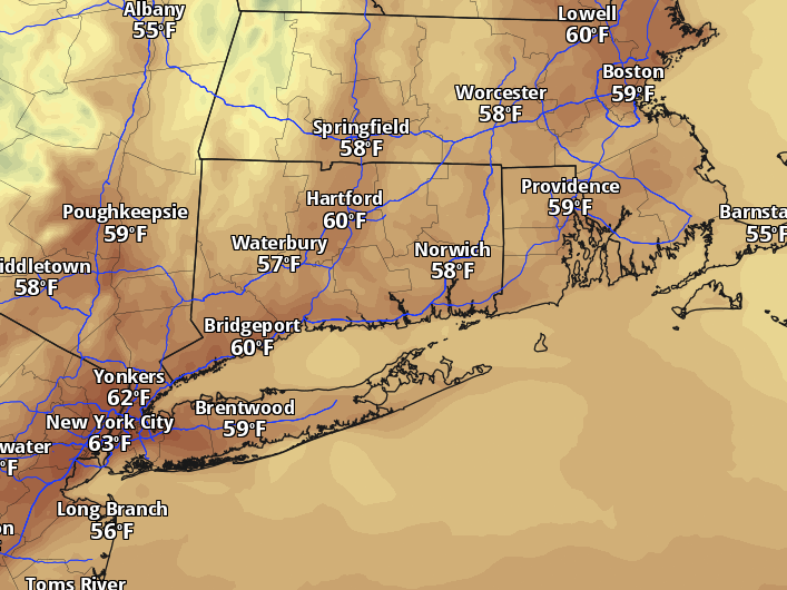
A stubborn ridge of high pressure is locking in another day of dry, unseasonably mild weather across Connecticut on Wednesday, pushing afternoon highs into the low 60s before a weekend pattern shift threatens to break the streak, CT Insider reported.
The setup is classic late-autumn synoptics: a strong ridge anchored over the Northeast delivering subsidence, crystal-clear skies, and a warming trend that runs 10 to 15 degrees above normal for mid-November.
After a chilly start in the 30s and 40s — with sheltered inland valleys potentially dipping a touch lower Wednesday night — sunshine will drive temperatures through the 50s by late morning. A light west breeze develops by afternoon, but it lacks the fetch to stir up anything more than a few high clouds.
“Our current dry and bright stretch also features a warming trend,” the First Alert Weather Team at WFSB wrote in their technical discussion Monday. “As a strong ridge of high pressure dominates, the remainder of the workweek will feature plenty of sunshine. Also, temperatures will trend up, day-by-day, turning unseasonably mild with highs today through Friday reaching the low to mid-60s.”
The regional breakdown
The warmth won’t be uniform. Shoreline communities from Stamford east to New London will top out between 58 and 62 degrees, moderated by a Long Island Sound still holding onto summer heat. Inland corridors — Danbury, Waterbury, Greater Hartford, and Windham — climb a degree or two warmer, 59 to 63. The Litchfield Hills run cooler, 55 to 60, thanks to elevation and efficient radiational cooling overnight.
The pattern breaks Sunday
Friday marks the last fully dry, fully bright day. Saturday holds onto sunshine, but a storm system approaching from the west begins saturating the column Sunday. WFSB’s guidance has trended slower with the arrival: showers now look most likely Sunday night into Monday, though the track remains uncertain enough that rainfall amounts are still anybody’s guess.
What isn’t in doubt is the temperature crash behind the front. Northwesterly flow kicks in Monday night, and by Tuesday highs struggle to escape the 40s — below average for the first time in weeks.
The first widespread frost of the 2026–27 season arrived October 7, when Bradley Airport bottomed out at 34 degrees — the coldest reading since April 25. That chill feels like a different season compared to the air mass in place this week.
Next rain chance: Sunday night. Next real cold: Tuesday.
Worth a look

Augusta University Honors Veterans; Military-Affiliated Enrollment Reaches 1,898
Augusta University honored its military community on Veterans Day with a pin ceremony and armed forces salute at...

Tulane Heads to Ruston Thursday Trying to Stop Two-Game Slide
Tulane heads to Ruston Thursday night trying to stop a two-game slide against a Louisiana Tech team that...

Kentucky Women’s Golf Signs Alabama’s Top-Ranked Junior Anna Christian Beeker
Kentucky women's golf secured its second major commitment for the Class of 2027 on Wednesday when Alabama's top-ranked...

Touché Amoré Announce 2027 Indianapolis Headlining Show at Turntable
Los Angeles post-hardcore band Touché Amoré will perform at Turntable in Indianapolis on April 21, 2027, as part...