
Southeastern Massachusetts Braces for Heavy Rain and Potential Flooding
A flood watch is in effect for parts of southeastern Massachusetts, as a significant weather system moves through the region this weekend. According to the National Weather Service, residents should prepare for widespread rainfall that is expected to persist through Saturday morning. Meteorologist Bryce Williams of the NWS Norton office reported that the heaviest downpours are concentrated in the southeastern portion of the state, with widespread totals expected to reach 2 to 4 inches, while isolated areas could see as much as 5 to 6 inches, Wicked Local reported.
The timing of this weather event puts the region on high alert through the next 12 to 18 hours. While the rain is expected to moderate as Sunday approaches, the immediate concern remains the sheer volume of water falling in a short window. The National Weather Service has issued a flood watch that remains active through 10:00 a.m. on Saturday, Nov. 7.
Localized Risks and Infrastructure Concerns
Beyond the raw precipitation totals, the primary concern for local communities involves the capacity of existing drainage systems. NBC10 Boston notes that while widespread severe weather is not currently anticipated, the combination of heavy rain and autumn conditions creates a specific risk for street flooding. In many areas, fallen leaves that have accumulated in storm drains may impede water runoff, potentially exacerbating the impact of the storm in low-lying spots or areas with historically poor drainage.
The impact is expected to be uneven across the state. While southeastern Massachusetts faces the highest risk, areas like Worcester are expected to see significantly less accumulation, with forecasts calling for up to an inch and a half of rain. Meanwhile, communities near Hyannis, Plymouth, Martha’s Vineyard, and Brockton are bracing for the brunt of the heavy rainfall period.
For those living in these zones, understanding how to respond to rising water levels is essential. Official guidance on flood safety emphasizes the importance of avoiding flooded roadways, as even a few inches of moving water can pose significant risks to vehicles and pedestrians alike.
Temperature Shifts and Weekend Outlook
The storm is bringing an end to a stretch of unseasonably mild weather. Saturday will see temperatures hovering in the lower 60s, but the mercury is expected to drop consistently through the remainder of the weekend. By Sunday, Nov. 8, highs are projected to reach only the upper 50s. NBC10 Boston reports that this cooling trend will be accompanied by a drier pattern by early next week, though some lingering showers could affect areas north of the Mass Pike on Sunday morning.
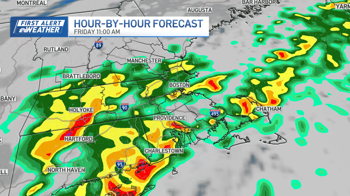
Despite the flood watch, the National Weather Service has indicated that no services are expected to be disrupted as a result of the potential flooding. The transition from heavy rainfall back to scattered showers and cloudy weather is anticipated to begin by mid-morning on Saturday, providing some relief to the region as the weekend progresses.
While the immediate threat of flooding will subside once the watch expires, the combination of saturated ground and falling temperatures marks a definitive shift in the regional climate as November progresses. For now, the focus remains on the next 12 hours, as the region navigates the peak intensity of the storm.
Related reading

Southern Nevada home sales slip as mortgage rates remain elevated
Southern Nevada Real Estate Stalls as Mortgage Rates Dampen Buyer Momentum The numbers from the latest Las Vegas...

Carroll Women’s Basketball Hosts Annual Champions of Character Game
More than 2,200 elementary and middle school students will descend upon the PE Center this afternoon, turning the...

Glasgow man dies in Boone County highway 40 crash involving a deer
Fatal Highway 40 Crash Claims Life in Boone County A Thursday evening collision on Highway 40 in Boone...

Kerby Joseph returns to Lions practice following knee injury
Kerby Joseph’s return to practice marks a significant shift for the Lions' secondary Detroit Lions safety Kerby Joseph...