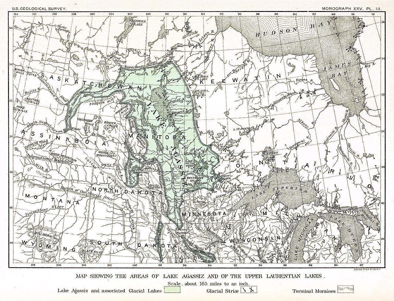
Lake Agassiz released up to 150,000 cubic kilometers of fresh water into the North Atlantic around 8,200 years ago.
The largest lake in North American history vanished before the pyramids were built, yet its ghost still dictates the weather, the farmland, and the flood maps of the upper Midwest.
Lake Agassiz covered 440,000 square kilometers at its peak — 1.8 times the combined surface area of all five Great Lakes and larger than the Caspian Sea. It stretched 700 miles long and 250 miles wide across what is now Manitoba, Ontario, Saskatchewan, Minnesota, and North Dakota, held in place by the retreating Laurentide Ice Sheet that blocked drainage into Hudson Bay.
The lake formed roughly 13,000 years ago as meltwater piled up behind that ice dam. It drained and refilled repeatedly, but a final catastrophic outflow around 8,200 years ago released up to 150,000 cubic kilometers of fresh water — roughly twelve Lake Superiors, or six and a half times the volume of the entire Great Lakes system — into the North Atlantic over a geologically brief period.
The sudden influx disrupted the Atlantic Meridional Overturning Circulation and triggered the 8.2 kiloyear event, the most pronounced abrupt cooling in the Holocene record. Global temperatures dropped an estimated 3.3 degrees Celsius in roughly 20 years, and the meltwater pulse added one to three meters to global sea level, redrawing every coastline on Earth.
Earlier outflows carved the valley of Glacial River Warren, a canyon 2 to 5 kilometers wide and 30 to 38 meters deep that now cradles the Minnesota River — a stream far too small to have excavated it.
The flat, fertile Red River Valley of North Dakota, Minnesota, and Manitoba is the former lakebed, floored with silt deposited over millennia of still water. That near-zero gradient is why the valley floods reliably every spring; Agassiz has been gone for eight millennia and is still filling the place up.
What remains are the scraps: Lake Winnipeg (24,514 square kilometers, larger than Lake Erie), Lake Manitoba, Lake Winnipegosis, Lake of the Woods, Red Lake, Cedar Lake, Lake Dauphin, and Lake St. Martin. Together they represent about 5.6 percent of Agassiz at its maximum.
The lake was first postulated in 1823 by William Keating and named in 1879 for Louis Agassiz, the Swiss-American naturalist who first recognized its glacial origin. The honoree never saw a drop of it; the lake had been dead for eight thousand years.
A hypothesis by Turney and Brown links an Agassiz drainage pulse to the westward spread of agriculture across Europe and suggests it may underlie flood narratives in ancient cultures, including the biblical account. That remains a proposed chain rather than a settled finding.
James Teller, professor emeritus at the University of Manitoba and a leading authority on the lake’s history, said we tend to think of geological time as slow, but Agassiz rewrote the map in a human lifetime. The Red River Valley floods of 1997 and 2009 are direct descendants of that ice-dam failure.
The numbers tell the scale best.
Lake Agassiz first appeared in scientific literature in 1823 when William Keating postulated its existence, though it was Warren Upham who named it in 1879 for Louis Agassiz, the founder of glaciology who had died in 1873. At its greatest extent the lake may have covered 440,000 square kilometers — an area approximately the size of the Black Sea and larger than any lake existing today.
Its final drainage around 8,200 years ago has been associated with a global sea-level rise of 0.8 to 2.8 meters, while an earlier outflow through the Traverse Gap carved a valley 2 to 5 kilometers wide and 30 to 38 meters deep that now holds the Minnesota River. North of that gap, the Red River of the North flows northward through the former lakebed to Lake Winnipeg, tracing the basin’s ancient floor.
For a lake that stopped existing before the invention of writing, Agassiz remains remarkably present — in the wheat fields on its bed, the spring floods in its valley, and the climate record written in ice cores halfway around the world.
Keep reading

Brake Rotor Tears From Tractor-Trailer, Kills Driver on I-84 in Tolland
"Brakes, tires, things strapped down in the back, those are the things we are looking for," said Matt...

UNL Student Arrested on Sexual Assault Warrant Seven Months After Campus Dorm Rape Report
University of Nebraska–Lincoln police arrested a student Tuesday on a first-degree sexual assault warrant, seven months after a...

Oregon Students Gather at Capitol as Visa Hurdles Drive International Enrollment Decline
About 65 college students from across Oregon gathered at the Capitol in Salem on Wednesday to tell lawmakers...

Juventus Stepping up Pursuit of Höjbjerg Amid FFP Constraints, Goal/Livescore Report
Juventus are stepping up their pursuit of Olympique Marseille midfielder Pierre-Emile Höjbjerg but face strict financial constraints that...