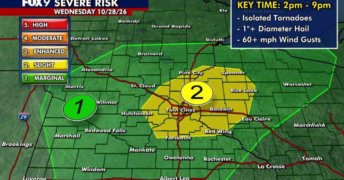
Minnesota residents face a Level 2 slight risk for severe weather this Wednesday, with the potential for isolated tornadoes, hail of 1 inch or larger, and wind gusts exceeding 60 mph. According to FOX 9, the primary window for these storms is between 2 p.m. and 9 p.m., with the highest risk for the Twin Cities metro area concentrated between 4 p.m. and 8 p.m.
The day begins with mild temperatures and humidity, though patchy sunshine will be interrupted as an area of low pressure moves across the state. This system is expected to spark scattered thunderstorms in western Minnesota during the early to mid-afternoon before the cells track eastward. While much of the state and western Wisconsin fall under a Level 1 marginal risk, the Twin Cities and surrounding regions are under the more urgent Level 2 designation.
The Risk of Isolated Tornadoes and High Winds
The severity of Wednesday’s weather depends largely on surface heating. Meteorologist Cody Matz reports that if temperatures climb high enough, the atmosphere could support the development of a strong tornado. Current forecasts place daytime highs in the 60s for central and southern Minnesota, with some southeastern areas reaching the 70s. The Twin Cities metro is expected to hit a high of approximately 67 degrees with southerly winds ranging from 5 to 15 mph.

For those in the path of these storms, the stakes involve more than just rain.
Northern Minnesota will experience a cooler day, with temperatures remaining in the 50s, though the broader movement of the low-pressure system remains the primary driver for the state’s instability.
Clearer Skies Arrive Thursday Before Variable Halloween Weather
The instability is expected to be short-lived. Once the storms move east, Wednesday night will settle into a quiet period with overnight lows dropping into the 40s. Thursday will bring a noticeable shift toward clearer conditions, featuring blue skies, a light breeze, and temperatures in the Twin Cities topping out just under 60 degrees.
Looking toward the end of the month, the weather remains variable. A few light showers or drizzle are possible on Halloween, followed by a warming trend that pushes temperatures back into the 60s by Sunday. This mild pattern is expected to persist into early next week, though additional chances for showers return on Monday and Tuesday.
| Region | Wednesday High Temp | Risk Level |
|---|---|---|
| Twin Cities Metro | 67°F | Level 2 (Slight) |
| Southern/Central MN | 60s | Level 1 (Marginal) |
| Southeastern MN | 70s | Level 1 (Marginal) |
| Northern MN | 50s | Level 1 (Marginal) |
The transition from a humid, storm-prone Wednesday to a brighter, sunny Thursday highlights the volatility of late October weather in the Upper Midwest.
Related reading

Massachusetts voters face nine ballot questions this election day
Massachusetts voters face nine distinct ballot questions this Election Day, covering a sweeping range of civic issues from...
Baltimore County Council Approves Pay Hikes for Top County Officials
The Baltimore County Council is moving to significantly increase salaries for top county officials and future council members...

Ari Laureano Alleges He Was Attacked With Flagpoles at Thorns Match
Ari Laureano opened his coat at a Portland Thorns match on Friday, Oct. 23, 2026, to reveal an...

Meredith Jean Mann Dies at 100 Years Old
Meredith Jean Mann of Flora passed away on Thursday, October 1, 2026, at St. Elizabeth Healthcare in Delphi,...