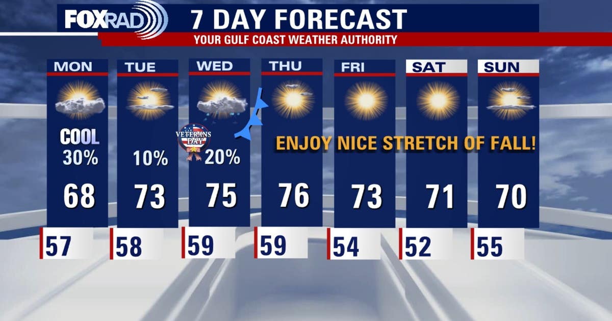
Houston residents can expect a transition from mild, damp conditions to much cooler temperatures as a cold front approaches the region later this week, according to Your Gulf Coast Weather Authority.
The weather pattern begins with a cooling trend on Sunday, as temperatures reached the mid to upper 60s across much of the area. Some urban locations saw highs peaking at 70 degrees.
Rainfall remains a factor for several communities in the immediate forecast. Areas southwest of Houston may experience periods of on-and-off showers, with a more pronounced impact expected toward Victoria County.
While much of the Greater Houston area deals with intermittent showers, the threat of heavy rain is more concentrated further south. Your Gulf Coast Weather Authority reported a Level 2 out of 4 risk for street flooding in South Texas on Sunday.
This flooding risk is expected to diminish slightly on Monday, dropping to a Level 1 out of 4 risk. The primary concern for these southern areas remains the potential for sudden accumulation on roadways during heavy downpours.

The upcoming week will maintain a damp character for several days. Monday may bring a few scattered showers, while thick cloud cover is expected to keep afternoon highs within the upper 60s to low 70s.
Tuesday offers a brief reprieve, as rain chances are projected to drop across the region.
A shift in air mass is scheduled to arrive late Wednesday into early Thursday. This approaching cold front is expected to trigger the development of coastal showers midweek.
Once the front clears the region, temperatures will drop sharply to end the week. Residents should prepare for a sharp contrast in daytime and nighttime conditions.
The following table illustrates the projected temperature shift for the Greater Houston area as the front passes:
| Day | Expected High Temperature | Expected Low/Wake-up Temperature |
|---|---|---|
| Wednesday | Upper 70s | — |
| Thursday | Upper 70s | — |
| Friday | Low 70s | 40s to 50s |
| Saturday | Low 70s | 40s to 50s |
The most notable change occurs during the overnight hours. By Friday and Saturday, morning temperatures across the Greater Houston area are expected to fall into the 40s and 50s.
Keep reading
- Utah at Arizona Scheduled for Nov. 14 at 5:30 P.m. on Fox
- Lost Vital Documents Create Barriers to Housing for Anchorage’s Homeless
- Nvidia CEO Jensen Huang faces bipartisan congressional scrutiny over China spy links (newsarchyuk.com)
- Hinojosa Can Pause Texas Data Center Permits, but Not Repeal the Tax Break (daybreakwire.com)

Utah at Arizona Scheduled for Nov. 14 at 5:30 P.m. on Fox
The Big 12 has scheduled a prime-time matchup between undefeated No. 2 Utah and No. 22 Arizona for...

Lost Vital Documents Create Barriers to Housing for Anchorage’s Homeless
“When they become homeless, they lose their identity,” Mike Hill said. The outreach specialist and housing navigator with...

U.S. Jobs Add 165,000 in October as Unemployment Drops to 4.1%
The U.S. economy added 165,000 jobs in October, exceeding the 65,000 new positions economists had anticipated, according to...

Photos: 40th Annual Palm Springs Pride Parade Celebrates LGBTQ+ Community
Palm Springs celebrates 40 years of Pride Thousands of people lined Palm Canyon Drive on Sunday morning to...