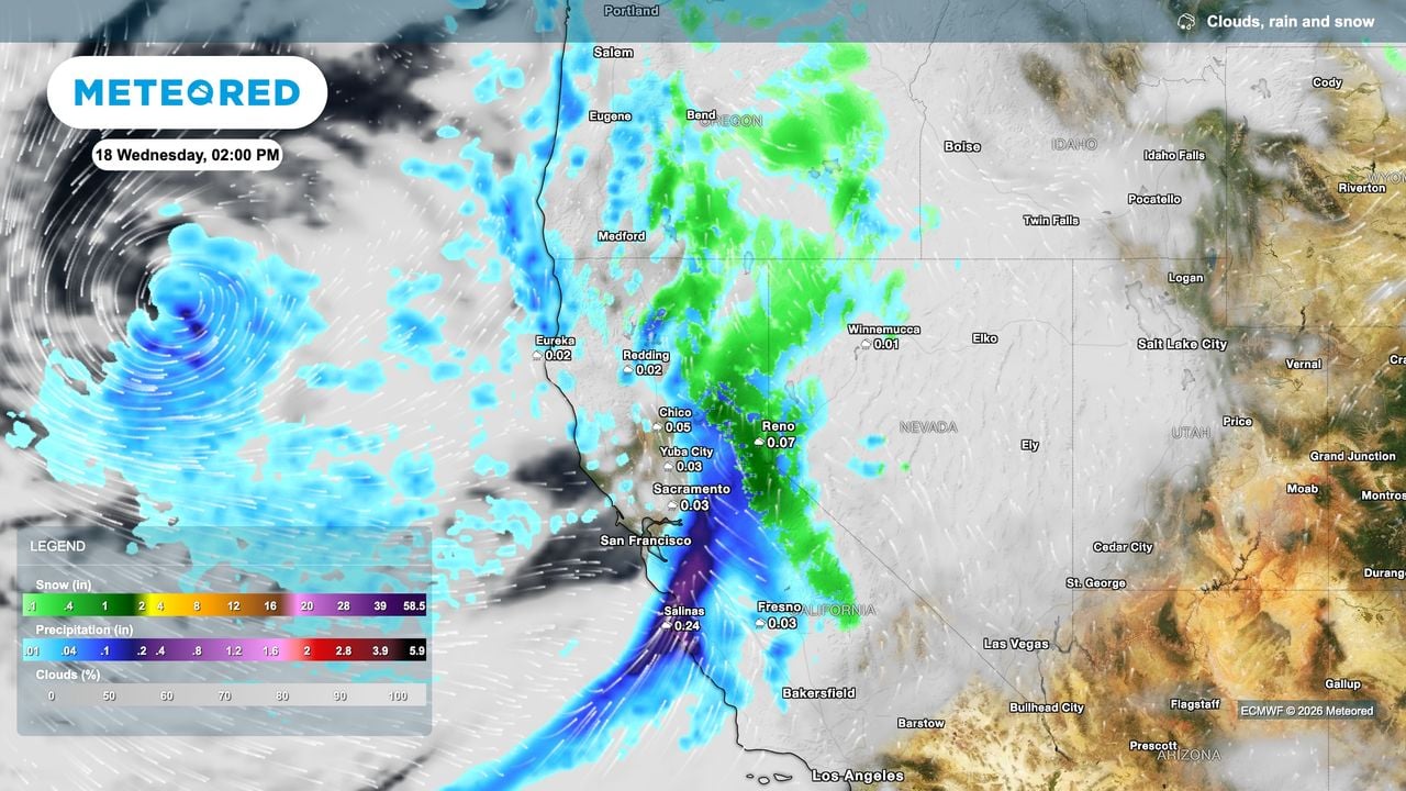
Atmospheric rivers are lining up across the northern Pacific like freight cars, and the first one slammed into Northern California on Wednesday, turning San Francisco streets into rivers and launching manhole covers into the air.
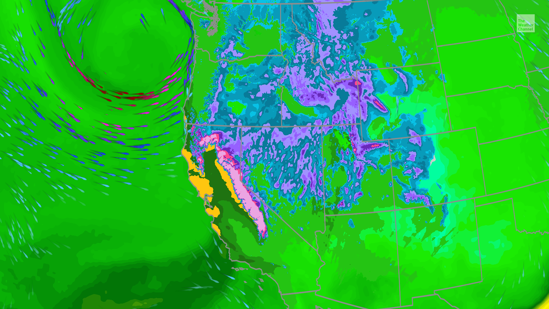
AccuWeather reported that the initial storm in a train of at least three will hammer the region into Thursday night, dropping a general 1 to 4 inches of rain on the coast and valleys while burying the Sierra Nevada under 2 to 4 feet of snow above 5,500 feet. The AccuWeather Local StormMax™ calls for 8 inches of rain and 6 feet of snow on the highest ridges through Friday.
“By the end of next week, the higher elevations of the Sierra Nevada may have 10-15 feet of snow on the ground, combining all the storms,” AccuWeather Chief On-Air Meteorologist Bernie Rayno said.
The National Weather Service warned in a Winter Storm Warning covering the Coastal Range above 4,000 feet, Shasta County Mountains above 4,000 feet, the Sierra above 4,000 feet, and southern Cascades above 4,000 feet that travel could be very difficult to impossible Tuesday night through 4 a.m. Friday.

Blizzard conditions shut mountain passes
Whiteout conditions and snowfall rates of 1 to 2 inches per hour will make travel through the Sierra “very difficult to impossible” into Thursday night, the National Weather Service warned.
Winter Storm Warnings are active for the Coastal Range, Shasta County Mountains, the Sierra, and southern Cascades above 4,000 feet through 4 a.m. Weather.com noted ridgetop gusts could hit 100 mph in the northern Sierra, while AccuWeather forecast frequent gusts of 40 to 60 mph with localized bursts to 80 mph, threatening widespread tree damage and power outages.
Donner Pass — the critical Interstate 80 corridor — faces slippery travel Saturday afternoon through Sunday morning as a second, weaker system adds a few more inches, AccuWeather reported.
Urban flooding strands Bay Area
Wednesday’s deluge turned San Francisco intersections into churning brown rivers. Geysers erupted from storm drains and autonomous taxis sat stranded in floodwaters, AccuWeather reported. Flash Flood Watches cover the California coast where soils, given no time to dry between systems, turn each new round of rain into an immediate runoff threat.
Weather.com highlighted the slight risk of excessive rainfall for central California Wednesday and Southern California Thursday, noting isolated mudslides are possible near recent burn scars and rockslides in canyon terrain.
AccuWeather forecasts the heaviest rain Wednesday into Thursday for San Francisco and Sacramento, with a secondary pulse reaching Los Angeles and San Diego late Wednesday night through Thursday. Motorists face ponding and near-zero visibility on freeways.
Weekend break before the Thanksgiving week punch
Friday offers a brief window for cleanup before storm number two arrives Saturday into Sunday. It is “arguably the least intense” of the series, AccuWeather said, but still packs enough moisture to flood poor-drainage areas in Northern California and southern Oregon.
A drier Monday sets the stage for a more potent third storm Tuesday through Wednesday — the heart of Thanksgiving travel week — renewing flash flood threats from Northern California to southern Oregon and heavy, road-closing snow for the Sierra.
King tides meet massive swells
The late-week storm coincides with some of the highest astronomical tides of the year. AccuWeather warned the combination could produce some of the highest water levels on record for California, driving dangerous sneaker waves and flooding overwash in beach communities. Weather.com added that 50-foot offshore swells will generate large breaking waves along the coast through the period.
The Sierra Nevada stretches roughly 400 miles north to south along California’s eastern edge, its crest rising to 14,505 feet at Mount Whitney, the highest point in the contiguous United States. Granite formed deep underground more than one hundred million years ago, but the range began its dramatic uplift less than five million years ago, with glaciers later carving Yosemite Valley and exposing the pale cliffs that define the landscape.
Spanish for “snowy mountains,” the name first appeared on a 1776 map by Pedro Font. The 1848 gold rush unfolded in its western foothills, yet the high country remained so remote it was not fully explored until 1912. Today the range holds three national parks and the largest alpine lake in North America, Lake Tahoe, while its western watersheds feed the rivers that sustain the Central Valley and the Bay Area.
Snowpack boon with a sharp edge
The Sierra snowpack is the state’s largest reservoir, and this parade will fill it rapidly. Weather.com noted the West relies on that frozen reserve for dry-season water supply.
But the speed of delivery — feet of dense, wet snow in days — collapses the margin for safe travel and strains emergency response. The second half of next week, the storm track shifts north toward Washington, northern Oregon, and British Columbia, AccuWeather reported, extending the active pattern well past the holiday.
WV Higher Ed Commission Awards $1M to Expand Rural Healthcare Career Exposure
West Virginia just landed a million-dollar bet on its own teenagers. The West Virginia Higher Education Policy Commission...

CBS Sports Grades 2025-26 Transfer Portal Hauls: St. John’s a, Kentucky D, UNC C
CBS Sports released its first report card on the 2026 college basketball transfer portal cycle on Thursday, grading...

IDNR Hosts POW/MIA Christmas Ceremony Dec. 5 at Vietnam Veterans Memorial
The Illinois Department of Natural Resources will host its annual POW/MIA Christmas Remembrance Ceremony at 1 p.m. Saturday,...

Wyden Co-Sponsors Bill to Give Portland Leverage to Keep Trail Blazers
Sen. Ron Wyden has co-sponsored the Home Team Act, legislation that would force professional sports owners to give...