California’s Final Weekend of Clear Skies Before the Seasonal Shift
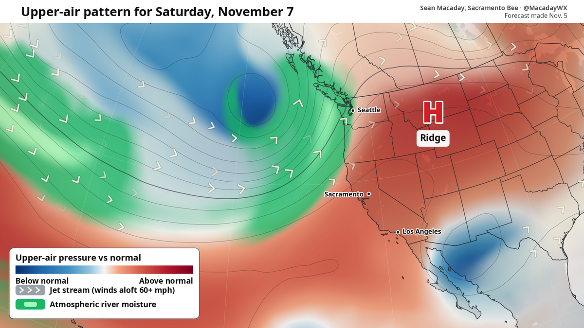
If you have plans to head to the coast or tuck yourself into the mountains this weekend, the timing is perfect. A weak ridge of high pressure is currently settling over the western United States, acting as a temporary gatekeeper that will keep California’s weather remarkably stable, sunny, and warm through the start of next week. According to meteorologist Sean Macaday, reporting for The Sacramento Bee, this pattern is providing a quiet window of opportunity before the region faces a significant shift in its weather narrative.
Across Central California, high temperatures are expected to settle comfortably into the upper 60s and low 70s. Further south, the influence of warmer ocean temperatures will push thermometers into the upper 70s and low 80s for coastal stretches from San Luis Obispo down to San Diego. Even in the higher elevations of the Sierra—ranging from South Lake Tahoe to Yosemite—conditions remain pleasant with highs in the upper 50s and low 60s. While these temperatures are slightly above the early November average, they offer a brief, calm reprieve before the arrival of a more volatile seasonal pattern.
The Approaching Atmospheric River
The serenity of this weekend is the calm before a looming change in the jet stream. Late next week, the ridge of high pressure that is currently shielding the state will push eastward, opening a door for a low-pressure system originating from the Gulf of Alaska. As this cooler air mass dives south, it is expected to collide with moist air associated with current El Niño conditions. This interaction is the primary ingredient for an atmospheric river—a phenomenon that can condense moisture and unleash substantial rainfall across the Golden State.

While the exact timing remains a subject of ongoing analysis, current meteorological signals point toward a wet period for Northern California and the Pacific Northwest between November 11 and November 16. The potential impact is significant: some areas could see more than their average November rainfall totals within just a few days. For residents and businesses, this represents a sharp pivot from the mild conditions of this weekend to a period where the primary concern shifts to managing potential heavy precipitation and mountain snow.
Understanding the Stakes of Early Winter Weather
In the world of climate modeling, a setup like this is a hallmark of strong El Niño winters. When the jet stream rapidly moistens, it can deliver long-lasting bouts of rain that fill reservoirs but also test local infrastructure. For those in the mountains, the shift is already underway; while the lower elevations are enjoying a final autumn warmth, the higher peaks are already seeing snow on the ground. Hiking in the high country has essentially become a seasonal challenge rather than a casual weekend outing.

The economic and civic stakes of these events are always tied to the state's water management and infrastructure readiness. However, the intensity of such rapid condensation events often highlights the tension between the need for water storage and the risks posed by sudden, heavy rainfall in sensitive watersheds.
It is important to recognize that while the forecast for mid-November shows a strong signal for moisture, the variability inherent in these systems means that localized impacts are difficult to project this far out. For now, the most practical advice is simple: enjoy the clear skies and light winds while they last. By the time the next work week concludes, the atmospheric environment will likely look very different, signaling the true, wet arrival of winter in the West.
Related reading

Oasis Charter High School Presents Almost, Maine at The Belle Theatre
Oasis Charter High School Brings 'Almost, Maine' to The Belle Theatre The aurora borealis serves as the backdrop...

Westlake Man Extradited to Baton Rouge for Alleged Double Rape of Two Women
A 20-year-old Westlake man is currently facing serious felony charges in East Baton Rouge Parish following a violent...

Ell-Saline and Wichita County face off in 2026 KSHSAA football playoffs
The 2026 KSHSAA football playoffs continue on November 7, 2026, featuring a high-stakes matchup between Ell-Saline High School...

Best Indiana Sports Gift Books for the 2026 Holiday Season
The 2026 Holiday Countdown and Indiana’s Championship Keepsakes With Black Friday arriving on November 27, 2026, shoppers have...