
Central Florida Faces Election Day Deluge
November is historically one of the driest months in Central Florida, a time when residents typically enjoy a respite from the heavy humidity of summer. This week, however, that seasonal pattern shattered. A stubborn low-pressure disturbance parked itself over the state, turning the start of the month into a relentless marathon of rainfall that has saturated the region from the coast to the interior.
The Orlando Sentinel reported that the weather pattern began Sunday morning and persisted through Monday, leaving schools closed, roads inundated, and residents under flash flood warnings. While the rain is expected to ease by Wednesday, the immediate impact on the region has been significant, particularly for those heading to the polls for Election Day.
Brevard County Bears the Brunt
The east coast saw the most severe conditions, with Brevard County experiencing what the National Weather Service characterized as life-threatening rainfall. In parts of Cocoa and Melbourne, totals exceeded a foot of water. The consequences were immediate and visible: motorists found themselves stranded as waterlogged engines stalled out on U.S. Highway 192.
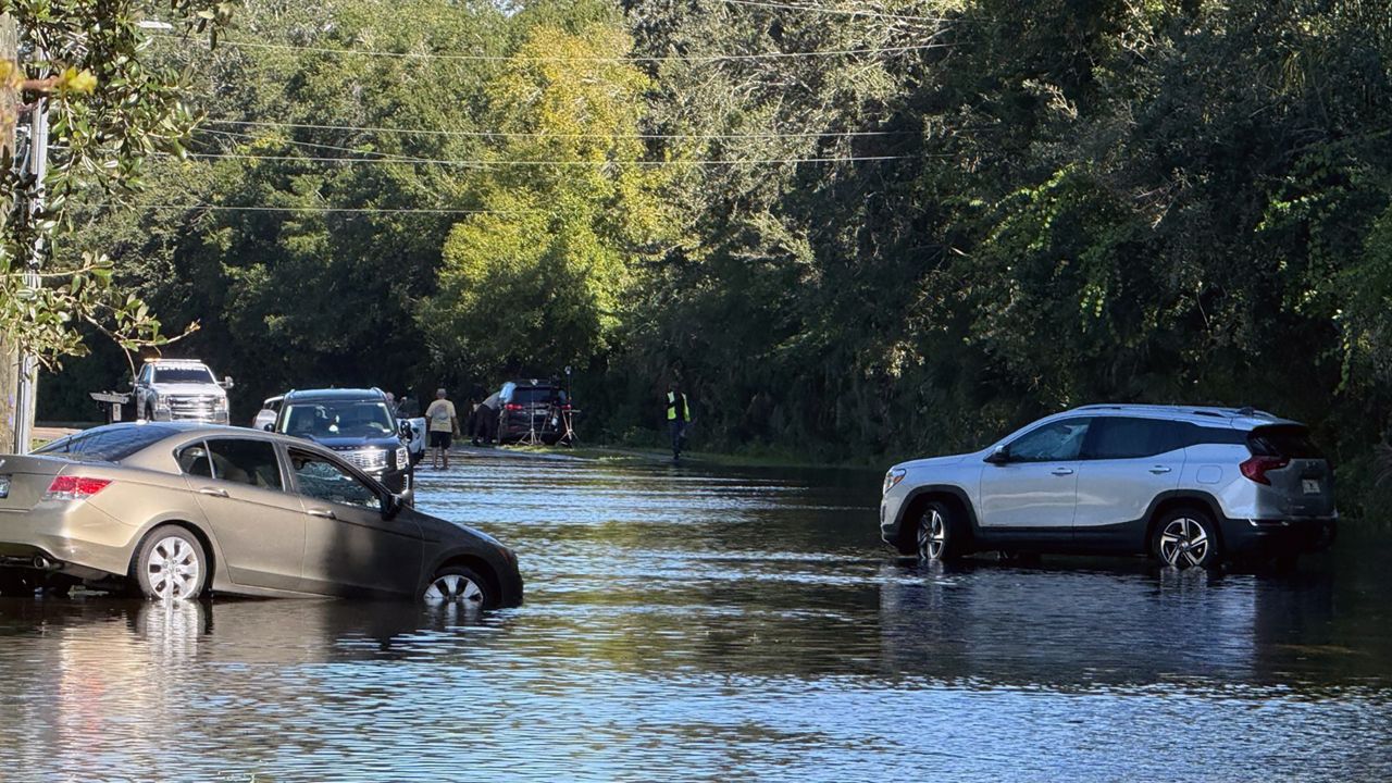
The scale of the flooding prompted a swift reaction from local institutions. Brevard County Public Schools canceled classes on Monday, citing the necessity of ensuring the safety of students and staff. “The safety of our students, staff and families is our top priority,” the district stated.
Farther inland, the story was much the same. Seminole County emergency officials reported 7.5 inches of rain by 8:00 a.m. Monday. The deluge strained local infrastructure, with ditches in the Black Hammock area reaching capacity and segments of County Road 426 becoming impassable. Orlando Sanford International Airport recorded more than three inches of rain during the same period, while Orange County saw some areas receive more than five inches—a figure that dwarfs the region’s typical two-inch monthly average for November.
Monitoring the Infrastructure
While the volume of water was substantial, the impact varied by geography. In Osceola County, emergency management director Bill Litton noted that despite rainfall totals reaching up to five inches near the Brevard border, the area avoided significant flooding. “We are monitoring Shingle Creek,” Litton said, noting that water levels remained just below the 59-foot action stage.
For those currently cleaning up, the forecast offers a tangible shift. National Weather Service meteorologist Zach Law confirmed that the moisture will begin to taper off, giving way to a more traditional Florida November. By Thursday, the region is expected to transition to sunny skies with highs in the lower 80s and cooler, comfortable overnight lows in the 60s.
The event serves as a stark reminder of the volatility inherent in Florida’s climate. Even as the state prepares for a return to dry conditions, the human and economic stakes—from stall-prone highways to the disruption of school schedules—highlight the fragility of local infrastructure when faced with unseasonal, concentrated weather events.
Worth a look
- Committee Recommends Denying Plan to Turn Mesquite Golf Course Into Homes
- Juneau Visitor Industry Task Force opens public testimony on tourism plans
- Honduras faces cáncer diagnostic limits and costs (archyde.com)
- Europe faces severe energy crisis and soaring debt amid Middle East wars (newsarchyuk.com)
Committee Recommends Denying Plan to Turn Mesquite Golf Course Into Homes
Paradise Valley Village Planning Committee recommends denial of Copper Residences project The Paradise Valley Village Planning Committee voted...

Juneau Visitor Industry Task Force opens public testimony on tourism plans
Juneau residents prepare to weigh in on tourism regulation proposals The City and Borough of Juneau’s Visitor Industry...

Huntsville rezones 800 acres and sees aerospace expansion in October
Huntsville marks October with massive land rezoning and aerospace expansion Huntsville is undergoing a significant physical transformation as...

Jacob Misiorowski Named NL Cy Young Finalist Among Brewers Four
Jacob Misiorowski stands as a heavy favorite to secure the National League Cy Young Award after finishing as...