Storms Threaten Election Day Polls as Cold Front Approaches Houston
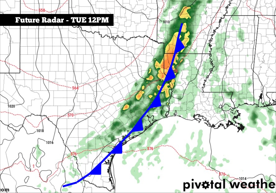
Voters heading to the ballot box in the Houston area on Tuesday could face disruptive thunderstorms, as a significant cold front sweeps across Southeast Texas just in time for Election Day.
The incoming system carries roughly an 80 percent chance of rain for the metro area, with the heaviest downpours expected between 11 a.m. and 4 p.m. Tuesday. While the storm is not projected to be a complete wash-out, forecasters expect rainfall totals ranging from 0.5 to 1.25 inches, with locally higher amounts possible across the region according to the National Blend of Models.
This weather shift follows a notably dry stretch for Houston. The city recorded just 3.57 inches of rain over the past three months—amounting to less than 25 percent of its historical average for that timeframe. Meanwhile, parts of the state further west absorbed heavy moisture late last month from Tropical Storm Vance. San Antonio logged 2.41 inches of rain between October 29 and 31, while the Del Rio area absorbed 4 to 6 inches.
Warm Start Before the Drop
Before the front clears the area, residents will endure unseasonably warm and muggy conditions. Sunday began with temperatures hovering near 70 degrees alongside patchy dense fog across Southeast Texas. That fog is expected to lift by late morning, pushing afternoon highs into the 82 to 83-degree range—roughly five degrees above average for the opening day of November. Monday will mirror those conditions, bringing morning lows near 70 degrees and afternoon highs climbing into the low-to-mid 80s.
The front itself will begin its march through North Texas by Monday evening, targeting cities like Abilene, Wichita Falls, and Dallas-Fort Worth before reaching the northern Houston metro area by 9 a.m. Tuesday. The system is expected to clear the region entirely by late Tuesday afternoon.
Clearer, Cooler Skies Ahead
Once the storms move out, the front will deliver a distinct taste of fall to Southeast Texas. Wednesday morning lows will dip into the low 60s, giving way to afternoon highs in the mid-70s under bright, clear sunshine. That cooler, dry weather pattern will anchor itself for the remainder of the week. Daytime highs will remain in the upper 70s on Thursday and Friday, while morning lows settle comfortably in the upper 50s to low 60s.
Keep reading

Martha Graham Dance Company Virginia Beach – Event Tickets Center
The Martha Graham Dance Company is scheduled to perform at the Sandler Center For The Performing Arts in...

Ousseni Bouda has early goal and assist to lead Earthquakes to 2-1 victory over Real Salt Lake
Ousseni Bouda struck early with a goal and an assist in the opening 17 minutes, propelling the San...

More than 7.4 million Texans voted early in 2026 election – The Texas Tribune
A record 7.4 million Texans cast their ballots early in the 2026 midterm election, pushing preliminary turnout to...

Immigration advocates sue Tennessee over new driver’s license restrictions – FOX 17 News
Tennessee Immigration Lawsuit Targets Driver's License Restrictions Immigration advocates have filed a federal-level legal challenge against Tennessee, arguing...