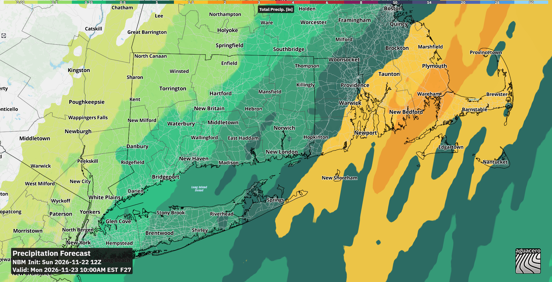
A coastal storm weakening over Connecticut tonight will give way to a potentially larger system that could disrupt Thanksgiving travel across the Northeast, forecasters said Sunday.
The first storm has trended east and weakened since Saturday, with rainfall projections dropping across western Connecticut, CTPost reported. Eastern areas still face one to two inches through Monday morning, while far western towns may see only a few tenths. Winds along the shoreline will gust 25 to 30 mph, with a “very low chance” of stronger gusts in southeastern Connecticut, the National Weather Service’s Upton, N.Y., office said. “AguaceroWx” model guidance shows the heaviest rain focused on southeastern Connecticut and eastern Long Island. The system’s quick movement should limit widespread flooding, though leaf-clogged drains may worsen ponding in low-lying spots. Rain ends by daybreak Monday, followed by a sharp temperature drop Tuesday and Wednesday, with highs only in the 40s. A strong 1,040–1,045 millibar high pressure system moving offshore will create a tight pressure gradient as the low approaches from the south, supporting wind gusts of 35 to 45 mph on Thanksgiving or Thanksgiving night, the Upton office said. “That tight pressure gradient is why it says gusts of 35 to 45 mph are possible on Thanksgiving or Thanksgiving night, along with moderate to heavy rain on the holiday itself,” the Upton forecast discussion said.
A full moon Tuesday produces exceptionally high tides — Boston expects 11.8 feet MLLW on Thursday and 11.7 feet Friday, “about as high as it gets,” the Boston office said. Many coastal locations need less than a foot of surge above normal to reach minor flood stage, and Upton’s current forecast “supports widespread minor to moderate flooding, perhaps even localized major.”
Model disagreement remains high. Mount Holly forecasters described confidence as “low overall,” with tracks ranging from inland — wetter and windier for the coast — to several hundred miles offshore.
An inland track would bring the heaviest rain and strongest winds to the corridor Thursday night into Friday. Precipitation will be almost entirely rain, with only a brief wintry mix possible in the Lehigh Valley, Poconos and northern New Jersey at the onset, Mount Holly said.
“Any subtle change can result in large differences in intensity, track, and timing,” the Upton office wrote. The forecast will firm up after the first storm clears Monday.
Keep reading
Nearly 25 Inches of Rain Floods Central Florida, Drives St. Johns River to 70-Year Highs
Central Florida recorded nearly 25 inches of rain in three days last week, driving the St. Johns River...

Deadtime Stories in Lansing May Close in June as Lease Expires
Deadtime Stories Books & Gifts, a horror and true-crime specialty shop in Lansing's REO Town, may close in...

Charleston Area Alliance Reports Spike in Ascend WV Remote Workers
The Charleston Area Alliance reported a spike in remote workers moving to the Kanawha Valley through the Ascend...

East Helena Wins First State Football Title, Beats Columbia Falls 35-9 in Snowy Class A Championship
East Helena won its first state football championship Friday night, beating Columbia Falls 35-9 on a snowy field...