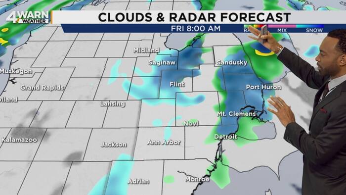
Southeast Michigan faces its first accumulating snowfall of the season on Friday as colder air sweeps across the region, bringing wet slush to northern communities while southern areas see mostly rain, ClickOnDetroit reported.
Winter weather is knocking on the door after a damp and blustery Thursday. Colder air moving into the region sets the stage for lake-effect rain and snow showers Thursday night into Friday.
Not everyone experiences the wintry mix the same way. Narrow bands of lake-effect precipitation determine where the snow actually sticks.
The greatest potential for accumulating snow spans Michigan’s Thumb, particularly near Saginaw Bay and along the Lake Huron shoreline. Areas in these zones could receive one to two inches of wet, slushy snow on Friday.

Communities near Sandusky and Port Huron face similar conditions, while areas around Flint can expect a coating of around an inch depending on where the snow bands develop. Farther south, Detroit, Ann Arbor, and most southern suburbs see little to no accumulation.
Northern Metro Detroit communities could pick up a light coating on grassy or elevated surfaces if a snow band stretches far enough south. Snowfall amounts vary considerably over relatively short distances under these conditions.
Lake Huron water temperatures remain in the 50s while overnight temperatures drop into the lower 30s. When colder air travels across the milder lake water, it picks up heat and moisture.
The moisture-rich air rises, cools, and condenses into clouds that produce bands of rain or snow downwind. This classic lake-effect process creates sharp contrasts in weather over short distances.
Road temperatures remain relatively mild following recent above-normal warmth, which limits initial accumulation on paved surfaces. However, heavier bursts of snow can briefly overcome that warmth to produce slush and reduce visibility.
Drivers navigating bridges, overpasses, ramps, and untreated roads face the highest risk of slick spots. Wet roads could also freeze late Friday night into early Saturday as temperatures drop.
Temperatures reach only the lower 40s on Friday with gusty winds pushing morning wind chills into the 20s. Lake-effect showers could linger in the Thumb into early Saturday before a gradual warming trend brings temperatures back toward 50 degrees by Tuesday.
Related reading

Former Eastlawn Principal NOT Guilty on All Counts of Sexual Assault
Former Eastlawn Elementary School principal Daniel McInnis was found not guilty on all counts by a jury on...

At 43, Robert Strauss Continues Training to Be the ‘Dad Bod Destroyer’ – Muscle & Fitness
At forty-three, former professional wrestler Robert Strauss still maintains the physical conditioning that earned him his signature moniker,...

Richmond Food and Drink News: New Eateries, Events, and Local Flavors
Two local transplants side-eyed each other at a restaurant, each wondering if the other was Filipino, before teaming...

Hofer Stops 29 Shots as Blues Defeat Mammoth in Shootout
Joel Hofer stopped 29 shots to help the St. Louis Blues defeat the Mammoth in a double shutout...