
“Winds this strong can make driving and walking dangerous,” the National Weather Service warned as a volatile weather system swept across the Hawaiian islands. A flood watch remains in effect for all main Hawaiian islands through late tonight, as a band of heavy showers and isolated thunderstorms moves slowly east across the state.
The current system is creating a high-risk environment for flash flooding and hazardous travel. While conditions are expected to improve from west to east throughout the day, the immediate impact has already disrupted education and infrastructure, particularly on Molokai, where flooded roads forced the closure of all public schools today. This includes Kaunakakai Elementary, Kilohana Elementary, Kualapuu Elementary Public Charter, Maunaloa Elementary, Molokai Middle, and Molokai High schools, the state Department of Education confirmed.
Flash Flood Risks and School Closures
The heaviest rainfall this morning centered over the central part of the state. A line of downpours that soaked Oahu overnight pushed east toward Maui County and the Big Island. On Oahu, rainfall totals ranged from a half inch to 2 inches. While a specific flood advisory for Molokai was canceled at 9 a.m., the broader flood watch for the entire island chain persists.
The National Weather Service in Honolulu noted that the greatest threats are currently facing Oahu and Maui County. The danger stems from slow-moving storms that can “park” over mountains, dumping rain in short windows of time. This pattern often leads to overflowing streams and drainage channels, which can trigger property damage in low-lying urban areas and cause landslides on steep terrain.
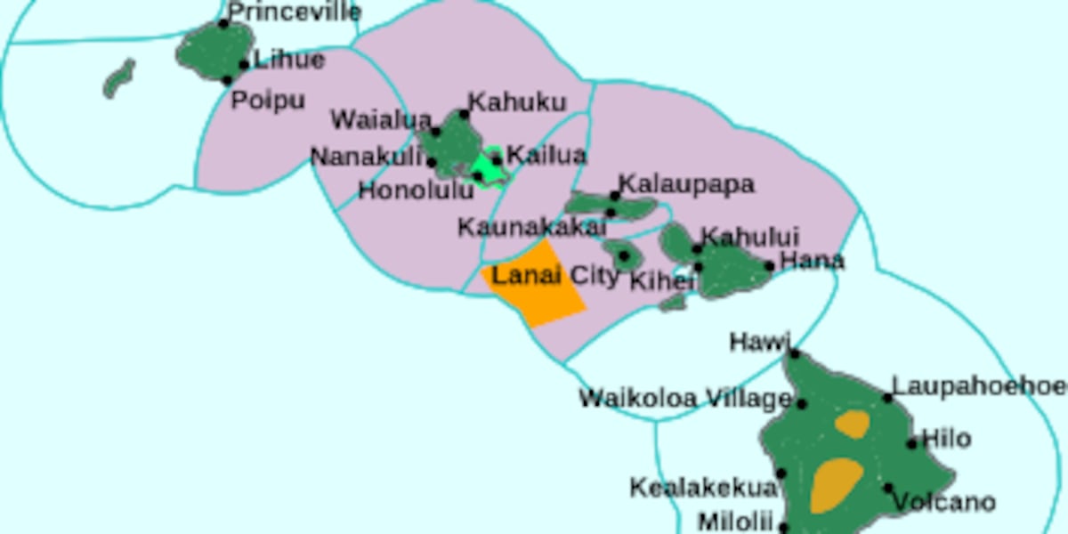
For those on the ground, the distinction between a “watch” and a “warning” is critical. As the National Weather Service explains, a warning indicates that flooding is either already happening or is imminent, requiring immediate action.
High Winds and Maritime Hazards Affect Big Island
While rain dominates the lower elevations, the Big Island’s summits are battling extreme wind. A high wind warning is in effect until noon today, with southwest winds of 30 to 40 mph and gusts reaching up to 65 mph. This is a decrease from the 80 mph gusts forecast on Tuesday, but it remains hazardous for pedestrians and drivers, especially those operating tall vehicles.
The instability extends to the coast. A small craft advisory is active until 6 p.m. for waters around Oahu and Maui County, specifically affecting the Kauai, Kaiwi, and Pailolo channels. A strong low-pressure system is driving east winds up to 25 knots (roughly 29 mph) north of the system and southerly winds to the south. According to the National Weather Service, isolated thunderstorms could produce erratic, gusty winds, making open waters dangerous for inexperienced mariners and small vessels.
Timeline for Recovery
The intensity of the current weather system is expected to taper off toward the end of the week. Hawaii News Now reports that the flood watch has been extended until Thursday morning for the entire state, driven by a disturbance moving from the west and an upper-level disturbance providing the instability necessary for thunderstorms.
The forecast for the coming days suggests a gradual return to normalcy:
- Thursday and Friday: The threat of heavy rain should ease, though humid conditions and spotty heavy downpours will likely linger. Highs will remain in the low to mid-80s.
- Friday Night to Saturday: Tradewinds are expected to return briefly.
- Sunday: Breezy northeast winds are forecast.
Ocean conditions will remain volatile. While the current northwest swell is dropping, a larger swell is expected to arrive late Saturday. This could push waves above the high surf advisory threshold by Sunday and Monday. South-facing shores are seeing above-average surf today.
For the residents of Molokai, the closure of six schools isn’t just a day off; it’s a systemic pause caused by the rapid rise of water in areas like Kawela Gulch, where officials had to extend advisories earlier this morning due to sudden flooding.
- Understanding microclimates in South-Central Kentucky – WBKO
- Billings eyes more parking at Amend Recreation Campus after busy weekend – KTVQ
- Fifth Circuit's 10-7 Ruling Closes the Constitutional Path to Bond (daybreakwire.com)
- John Healey drops welfare cuts timeline amid £28bn public finance shortfall (newsarchyuk.com)

Understanding microclimates in South-Central Kentucky – WBKO
South-Central Kentucky Experiences a 20-Degree Temperature Split Due to Local Microclimates Foggy and cold weather in one pocket...

Billings eyes more parking at Amend Recreation Campus after busy weekend – KTVQ
“We knew that there was going to be crazy busy,” said Chris Martin, facility supervisor at the Amend...

New Mexico US Rep. Leger Fernández’s bill would require mining companies to pay royalties
New Mexico Rep. Leger Fernández Unveils Landmark Bill to Charge Mining Firms Royalties, Block Foreign Extraction U.S. Rep....

Cole County plans $1.3 million facility renovation – ABC17NEWS
Cole County is planning an approximate $1.3 million renovation of its emergency services building as officials continue exploring...