Inside Climate News and the Pittsburgh Post-Gazette teamed up to build a streamlined, responsive interactive mapping tool that helps Pennsylvania residents easily locate hundreds of thousands of abandoned, orphaned, and historical oil and gas wells hidden across the state.
What the World’s First Oil Boom Left Behind
Western Pennsylvania’s geology resembles a huge block of Swiss cheese due to a long history of resource extraction. Edwin Drake struck oil less than 70 feet beneath the surface just south of Titusville in 1859, launching the world’s first commercial oil boom. Decades of subsequent drilling, alongside the modern-day fracking boom that started in 2004, added hundreds of thousands of wells into the area on top of existing coal mine tunnels.
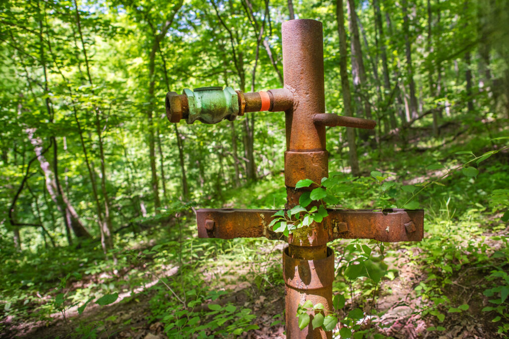
Many of these legacy wells have long since been abandoned, leaving behind former operators who went out of business or whose identities remain entirely unknown. While some old wells stay obvious through rusting pipes and protruding metal wellheads, many more lie hidden beneath forests, busy shopping centers, and public parks like the Pittsburgh Botanic Garden. Others rest directly underneath the terminal and runways of the Pittsburgh International Airport.
While numerous abandoned wells pose little hazard beyond a tripping risk, others present severe environmental and safety dangers. Defective wells can leak explosive methane, toxic carbon monoxide, and hazardous carcinogens like benzene into local air and water supplies. To address these risks, journalists Kiley Bense and Peter Aldhous analyzed state data to create a public-facing mapping tool that groups wells into four straightforward categories.

The oil and gas well mapping tool provided by the Pennsylvania Department of Environmental Protection can be slow and difficult for non-experts to use. The collaborative media project simplified this state data into active, plugged, abandoned or orphaned, and historical categories. Historical maps digitize older wells from southwest Pennsylvania, though they lack modern field verification and require extra caution from users.
Who Lives Near an Unplugged Well?
Suburban development has rapidly expanded over decades, sometimes landing directly on top of uncharted energy infrastructure. Reporting by Anya Litvak and Peter Aldhous used the interactive map to locate relatively new neighborhoods built directly over hundreds of old oil wells in Allegheny County.
Homeowners in places like the Berkshires neighborhood in South Fayette Township repeatedly discovered they had no prior awareness of the historical wells marked by purple dots on the mapping tool.
The Department of Environmental Protection maintains responsibility for the underlying data accuracy, but discrepancies remain common in official records. For instance, an old well named Jane McGill #1 located on the property of the Pittsburgh Botanic Garden was still listed as active by the state at the time of publication, even though it functions physically as an abandoned well.
The state inventory lacks coordinates for more than 29,000 wells, meaning thousands of unplugged hazards remain absent from digital maps entirely.

The state warns that an individual well might appear in both historical maps and actively maintained inventories, or appear duplicated with slightly shifted coordinates.
What Are the Warning Signs on the Ground?
Physical evidence often provides the only warning for residents living near undocumented extraction sites. Surface indicators of a nearby leaking well include dead vegetation patches, bubbling water features, rusted metal equipment, unexplained sinkholes, and distinct petroleum smells. State officials prioritize emergency plugging contracts for wells deemed direct threats to homes, schools, or public spaces.
When reporting concerns to regulatory authorities, residents must provide precise GPS coordinates for the well in question. Homeowners seeking to verify local water safety can utilize testing services offered by inventory analysis programs and academic institutions like Penn State University, which tests drinking water for oil and gas drilling pollution.
Worth a look

Nvidia Interim CEO Colette Kress Faces Pressure Over Family Roles After Jensen Huang’s Exit
Colette Kress, the longtime chief financial officer now serving as interim CEO, inherits a company where the former...

Residence Inn Seattle Northgate Station Reviews: Strong Suites and Transit Access Undermined by Housekeeping, Billing and Parking Complaints
Guest reviews for the Residence Inn by Marriott Seattle Northgate Station show a property praised for extended-stay comfort...

No. 6 Texas hosts Southern Utah at Moody Center Thursday
Texas hosts Southern Utah on Thursday at Moody Center, the Longhorns' first home game since a one-point escape...

Jamelia Brown Resigns From Richmond City Council, Creating Dual Vacancy
Jamelia Brown, the District 1 council member representing Belding Woods and the Iron Triangle, is stepping down from...