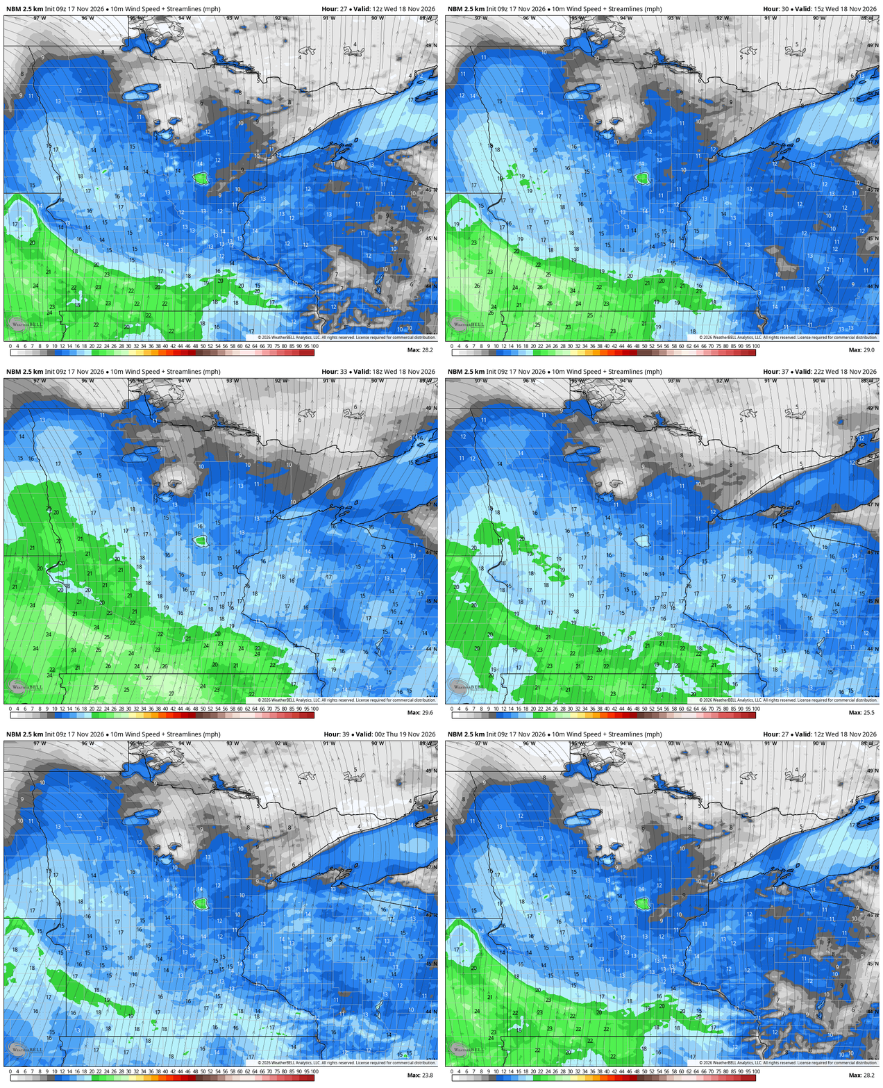
Minnesota remains stuck in an unseasonably warm and windy pattern through midweek, with highs in the 50s and low 60s running roughly 20 degrees above normal before rain returns late Friday, MPR News reported.
Cloud cover will dominate Tuesday as low clouds move across the region, yet temperatures will still reach the low to middle 50s. Southerly winds will gust 25 to 30 mph, mainly across southern and southwestern Minnesota.
Winds strengthen further Wednesday as a storm system passes to the northwest. Sustained winds of 20 to 25 mph are expected with gusts of 30 to 35 mph, and some locations along southwestern Minnesota’s Buffalo Ridge and across extreme southern Minnesota could see gusts approaching 40 mph.
High temperatures Wednesday could reach near 60 degrees in southern Minnesota. A dry cold front sweeps through Wednesday night, dropping readings slightly for Thursday with low to mid-40s north and low to mid-50s south.
Warmer temperatures return quickly Friday ahead of the next system. Temperatures are forecast to climb into the mid to upper 50s throughout central and southern Minnesota, while the south-central part of the state may see readings in the lower 60s. The next best chance for widespread rainfall arrives late Friday into Saturday as a storm system moves out of the Rockies and across the Central Plains.
Rainfall amounts of at least one-quarter inch look possible in many areas. While the system is not expected to bring the significant rainfall experienced earlier in November, it will be a welcome opportunity for some much-needed moisture.
Much cooler air will move into the region Saturday night into Sunday as the system moves away, and a few snowflakes could mix in, although the better chances for accumulating snow appear to remain well north of the area.
Worth a look
Ricardo Perez-Flores Charged With Illegal Reentry After Four Deportations
Ricardo Perez-Flores appeared in federal court Monday to face charges of illegal reentry after four prior deportations and...

Jefferson City Council Sets 2027 Election Date, Filing Window
The Jefferson City Council set the calendar for the 2027 municipal election on Monday, locking in April 6...

Omaha Unveils Snow Removal Plan for Downtown Streetcar Construction Zone
Omaha Public Works unveiled its winter snow removal strategy on Monday, centering the plan on a downtown corridor...

No. 2 Michigan State at No. 14 Tennessee: Time, TV Channel, Streaming & Odds (Nov. 17)
No. 2 Michigan State (4-0) visits No. 14 Tennessee (3-0) Tuesday at 9 p.m. ET on ESPN2 from...