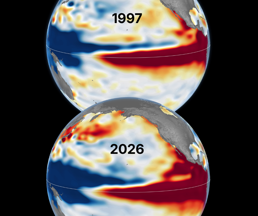
Meteorologists and climate researchers are looking back to the late 1990s as a new El Niño pattern takes shape in the Pacific. According to data released by NASA on October 23, current satellite imagery of sea-surface heights bears a striking resemblance to the conditions observed in October 1997. For residents of Connecticut, this historical echo invites a specific question: does a repeat of 1997’s Pacific conditions guarantee a repeat of that winter’s relatively snow-free landscape?
The connection lies in how we measure the Pacific Ocean’s thermal energy. Satellites cannot directly gauge water temperature at depth, but they can measure the elevation of the sea surface. As water warms, it expands; wind patterns then redistribute this heat across the equatorial Pacific. By tracking these height anomalies, NASA researchers have identified a clear link between the current 2026 event and the powerful 1997–98 El Niño, as reported by NASA’s Earth Observatory.
The 1997 Winter Benchmark
To understand what might lie ahead, it helps to look at the historical record for Connecticut. The winter of 1997–98 was defined by its notable lack of bite. At Bradley International Airport, the average temperature from December through February settled at 33.3 degrees—roughly 3.5 degrees warmer than the current 1991–2020 winter normal. The trend was even more pronounced in Bridgeport, where the average hit 36.6 degrees.
The snowfall totals from that season remain a point of reference for those hoping for a white winter. Bridgeport saw only 8.9 inches of snow during the 1997–98 season, a stark contrast to the modern seasonal average of 33.6 inches. While January 1998 saw warmer-than-average temperatures across the eastern United States, the lack of snow did not equate to a lack of moisture. Bridgeport actually recorded 11.84 inches of precipitation during those three core winter months, slightly exceeding its normal 10.28 inches. The precipitation arrived, but the temperatures simply weren’t cold enough to keep it on the ground as snow.
Atmospheric Dynamics and the Jet Stream
El Niño does not dictate weather in the Northeast with the same ironclad consistency that it influences the southern United States. Its primary mechanism of influence is the jet stream, the high-altitude ribbon of air that guides storm tracks. A strong El Niño often energizes the southern branch of the jet stream, which can steer storms across the southern U.S. and occasionally up the East Coast.
However, for Connecticut, the outcome depends on a delicate intersection of variables. A storm track that brings plenty of moisture can still result in a rain-heavy season if it draws in mild Atlantic air. Without the necessary cold air mass to anchor the storm, the result is often slush or freezing rain rather than significant accumulation. Other atmospheric phenomena, such as the North Atlantic Oscillation—which governs pressure systems near Greenland—can frequently override the influence of the Pacific, shifting the path of storms or opening the door for arctic air.
The Outlook for the Current Season
The current forecast leans toward a winter that is both warmer and wetter than average for Connecticut. While this configuration creates a high probability of active storm cycles, it also keeps the risk of mixed precipitation front and center. The 1997–98 season serves as a reminder that El Niño is not a singular predictor of snowfall, but rather a variable that shifts the odds.
One well-timed storm can drastically change the narrative of a season, regardless of the patterns unfolding thousands of miles away in the Pacific.

Leon County Ranks First in Florida for Single-Parent Households
Leon County sits at the top of a newly released demographic snapshot, recording the highest percentage of children...

Guide to Cape Fear Halloween Events and Celebrations
Communities across the Cape Fear region are rolling out a packed schedule of Halloween celebrations for Friday, Oct....

Shawn Langdon Powers to Provisional No. 1 at NHRA Las Vegas Nationals
Las Vegas Opening-Day Leaders Set the Pace at NHRA Nationals Friday at The Strip at Las Vegas Motor...

Colorado Gives Day Early Donations Open for Statewide Nonprofits
Colorado Gives Day is expanding its annual philanthropic push into a five-week fundraising window, opening early-giving options on...