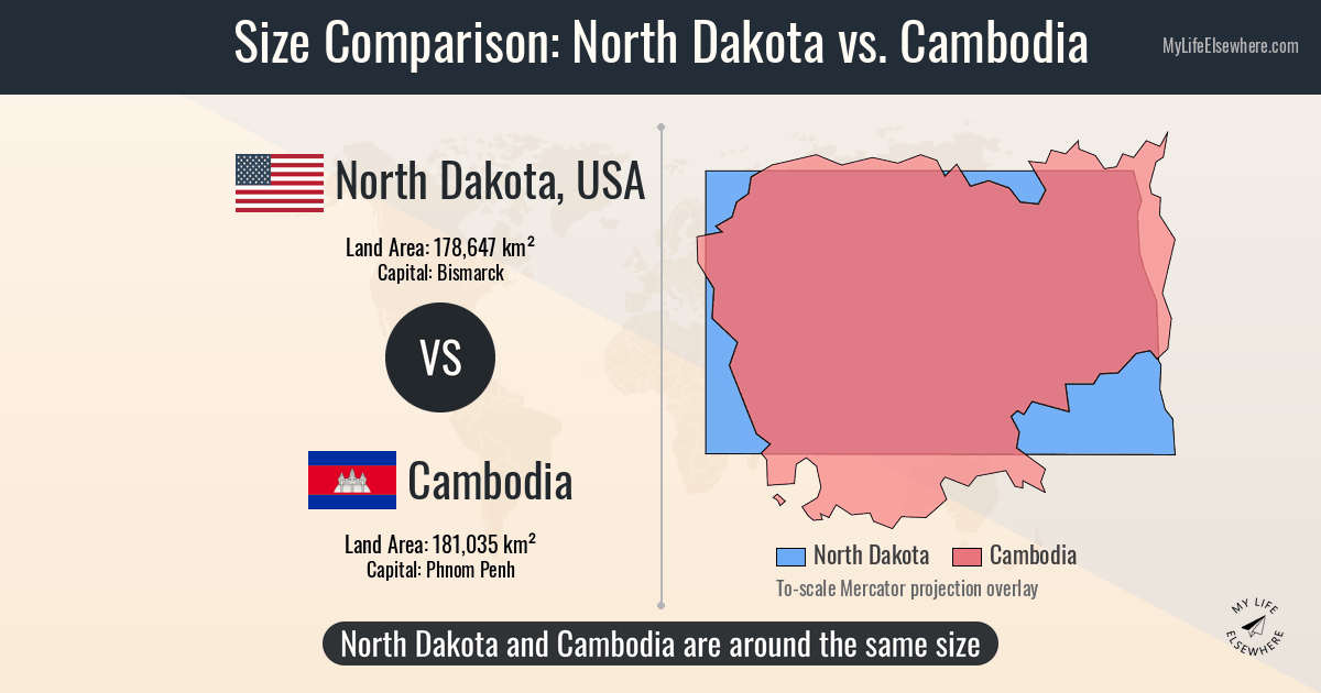
North Dakota and Cambodia occupy almost the exact same footprint on the planet — separated by roughly 800 square miles — but a new mapping analysis shows the Mercator projection makes the Midwestern state look more than twice the size of the Southeast Asian nation.
The comparison, published by the cartographic tool MapGO, places the two side by side on an equal-area projection. North Dakota spans 70,698 square miles (183,108 km²); Cambodia covers 69,898 square miles (181,035 km²). That puts Cambodia at 98.9 percent of North Dakota’s total area, a difference smaller than the state of Rhode Island.
“Most web maps, Google Maps among them, use the Mercator projection, which stretches land more the farther it lies from the equator,” MapGO reported.
At roughly 48 degrees north, North Dakota is drawn about 2.2 times its true area; Cambodia, sitting near 13 degrees north, is stretched only about 5 percent. The result: on a standard Web Mercator map, North Dakota appears roughly 2.1 times larger than Cambodia, even though they are near twins in reality.
The population picture flips the script entirely. Cambodia holds about 18 million people, per 2025 estimates, while North Dakota recorded 779,094 residents in the 2020 census. That makes Cambodia roughly 23 times more densely populated — 255 people per square mile versus North Dakota’s 11.
The projection problem
Mercator was built for 16th-century navigation, preserving bearing at the expense of area. The distortion accelerates with latitude. Greenland, famously, looms larger than Africa on a Mercator map despite being 14 times smaller. North Dakota suffers the same inflation; Cambodia, hugging the equator, escapes it.
MapGO’s analysis draws on Copernicus DEM GLO-90 elevation data sampled at roughly 1,000 points per territory and area figures from Wikidata, which for U.S. states mirrors the Census Bureau’s total-area numbers. The outlines come from Natural Earth public-domain vectors, simplified for display but not used for measurement.
Context from a wider lens
A separate size-comparison tool, r0ice.com, places North Dakota in a global lineup. At 70,503 square miles (183,000 km²) by their equal-area calculation, the state outranks 109 of the world’s 197 countries. The closest sovereign matches cluster tightly: Belarus, Kyrgyzstan, Senegal, Syria, Uruguay, Tunisia, Nepal, Suriname, and Tajikistan all sit within roughly 20 percent of North Dakota’s footprint. Cambodia remains the nearest peer.
For scale, r0ice.com notes Japan is twice the size of North Dakota, Germany twice, France 3.5 times, and the United Kingdom 1.3 times. Brazil dwarfs it by a factor of 47; Russia by 92.
| Metric | North Dakota | Cambodia |
|---|---|---|
| Total area | 70,698 sq mi (183,108 km²) | 69,898 sq mi (181,035 km²) |
| Population (latest) | 779,094 (2020) | ~18 million (2025) |
| Density | 11/sq mi (4.3/km²) | 255/sq mi (99/km²) |
| Highest point | White Butte, 3,507 ft (1,069 m) | Phnom Aural, 5,948 ft (1,813 m) |
| Average elevation | ~400 ft (122 m) | — |
Elevation tells another story. North Dakota’s average height, measured from the Copernicus model including tree canopy and structures, sits around 400 feet. Cambodia’s average was not published in the dataset. But the peaks diverge sharply: White Butte tops out at 3,507 feet, while Phnom Aural in the Cardamom Mountains reaches 5,948 feet — nearly 2,441 feet higher.
The capitals highlight the human contrast. Bismarck governs a state where you can drive hours between towns. Phnom Penh, a metro area pushing millions, anchors a country where rice paddies and motorbike traffic pack the lowlands.
Data retrieval timestamps show MapGO pulled country figures on October 9, 2026, and U.S. state figures on November 19, 2026. The r0ice.com comparison uses Natural Earth borders measured on the globe, so its area numbers can differ slightly from official figures that count inland water differently.
Cambodia’s modern borders trace to the Khmer Empire, which from 802 AD united the region for six centuries and spread Hinduism then Buddhism across Southeast Asia. After centuries of decline and territorial loss, it became a French protectorate in 1863 and part of French Indochina until independence in 1953.
The Khmer Rouge regime carried out a genocide from 1975 to 1979; Vietnamese intervention ended it, but insurgencies continued until 1999. A 1993 UN peacekeeping mission restored the monarchy and established a democratic constitution. The country is dominated by the low-lying Mekong plain and Tonlé Sap, Southeast Asia’s largest lake.
The takeaway is simple: the map on your phone lies about North Dakota. Drag the two outlines onto an equal-area projection and they snap together like puzzle pieces — same ground, radically different worlds.
Keep reading

Minneapolis Council Rejects Police Chief Nominee 8-5, Mayor Vetoes Rejection
Minneapolis City Council voted 8-5 last Thursday to reject interim Police Chief Bill Peterson’s nomination for the permanent...

Alabama Sen. Arthur Orr Plans Bill for Three-Year Bachelor’s Degrees at Public Colleges
Alabama Sen. Arthur Orr plans to file a bill for the next legislative session that would let public...

Massachusetts Cannabis Commission Claims Oversight of Intoxicating Hemp
“When I look at this from a social justice perspective, we are being intentional with where we have...

College Football Week 12 Top 10 Games: Georgia-South Carolina, LSU-Tennessee Highlight Slate
Only one ranked-versus-ranked matchup dots the Week 12 slate, and the line on it sits above two touchdowns....