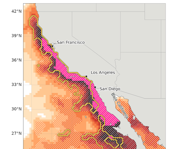
Ocean temperatures along the California coast have reached levels more than 10°F warmer than average, stretching in a contiguous region from central Baja to Sonoma County, Weather West reported.
This unprecedented marine heatwave is setting the stage for a volatile transition in weather patterns. Data indicates that these water temperatures are not just record-breaking for this specific week, but are “record-shattering” for any cool-season week between November and April since satellite records began in 1981. The warmth is particularly extreme near the Farallon Islands, where temperatures have exceeded 66°F, breaking all previous records for this time of year.
The implications of this thermal anomaly extend beyond marine biology. The heat is driving physical changes to the coastline. Thermal expansion of the seawater is currently causing coastal ocean levels to run 6 to 12 inches above average.
This rise in water levels, combined with the arrival of “king tides” between late November and late January, creates a high risk for damaging coastal flooding. Should a significant tempest strike within any of these designated timeframes—even a relatively mild one—sea levels might climb even higher, adding an extra 1 to 2 feet.

“These are the kind of anomalies that made me do a double take, and recheck the data to make sure it’s not in error–it’s just that incredible,” said Daniel Swain.
Successive storm waves to soak the state
While the ocean warms, the atmosphere is preparing to shift. A sequence of three to four successive winter-like storms is expected to arrive in California over the next nine days. The first wave is projected to hit Northern California this Friday. Ensemble models suggest that rainfall accumulations across much of California over the next 14 days generally exceed average totals for the entire month of November!
The meteorological setup is complex. These systems are expected to be associated with a fairly strong overhead jet stream and cold air aloft. When this cold air moves over the exceptionally warm near-shore waters, it creates atmospheric instability. This could lead to more frequent and widespread thunderstorm activity than is historically typical for California winter storms.
The potential impact varies by region. While Northern California prepares for its first heavy rainfall of the season, Southern California is also expected to see heavy precipitation, though perhaps with a slight delay in the timing of the heaviest totals.
Ocean temperatures and rainfall deviate from seasonal averages
The current environmental data shows a stark departure from historical norms. The following table compares the current ocean and precipitation trends against seasonal averages based on recent modeling and observations:
| Metric | Current Observation / Forecast | Typical Seasonal Average |
|---|---|---|
| San Francisco 15-day rainfall (ECMWF ensemble) | 1 to 5+ inches | ~2.6 inches (monthly average) |
| Coastal ocean level anomaly | 6 to 12 inches above average | Standard tidal levels |
The drivers of an extreme winter
Meteorologists attribute this extreme environment to a “stacking” of multiple factors. An exceptionally strong El Niño is currently developing, which is likely to have major impacts on California through the winter months of December through March. This El Niño is building upon a pre-existing marine heatwave that has been amplified by long-term ocean warming linked to human-caused climate change.
The timing of the El Niño pattern appears to be ahead of schedule. While the coupling between ocean anomalies and the North Pacific jet stream often takes until December or January, the large-scale pattern is already manifesting.
Worldwide climate prediction hubs are presently generating some of the most precipitation-heavy seasonal outlooks ever produced for the Golden State, surpassing past model runs for the notorious 1997-1998 season and leaving the more modest retrospective projections for 2015-2016 far behind.
The civic stakes are high for coastal communities and infrastructure. Beyond the immediate risk of urban flooding due to clogged storm drains and saturated watersheds, the combination of rising sea levels and storm surges threatens coastal erosion. For the agricultural and marine sectors, the arrival of certain subtropical species in parts of California where they’ve never been seen before changes the local ecology.
The transition to this active, stormy pattern is expected to continue as the state enters the core of the rainy season. Current seasonal modeling suggests that the extreme sea surface temperature anomalies along the immediate coast are likely to persist through at least January or February.

Keep reading
St. Paul Apartment Building Demolished Following Devastating Fire
Thick smoke billowed from a four-story building on Monday as St. Paul firefighters climbed an aerial ladder toward...

Students Scrutinize MSU Police Alert Policy After Halloween Shootings
Michigan State University police sent an off-campus safety alert for couch burnings on Saturday following criticism over missing...

What Jaylen Brown Said of His Icy Response to Jayson Tatum’s Dap
Jaylen Brown offered no acknowledgment to former teammate Jayson Tatum during a pregame dap attempt at Xfinity Mobile...

Maine Fire Chiefs President Views Robbins Lumber Probe as Learning Opportunity
Liberty Fire Chief Bill Gillespie, president of the Maine Fire Chiefs Association, is framing the state’s investigation into...