
Southern California is preparing for a potentially historic shift in weather patterns as a “Super El Niño” moves into position. While residents are no strangers to the cycle, current forecasts suggest this season could bring above-average rainfall and significant environmental risks, according to a report by Daily News.
The phenomenon is driven by a surge in tropical Pacific water temperatures that have risen several degrees above the normal El Niño range. This warming is compounding a large marine heat wave that has been active since spring 2025, creating a layered heating effect that meteorologists warn could intensify the upcoming season’s impact.
The mechanics of a warming Pacific
El Niño occurs naturally every two to seven years when trade winds weaken, allowing warm water to build up in the tropical Pacific. This process often triggers Kelvin waves—large, slow-moving pulses beneath the ocean surface—that eventually push heightened sea levels and warm waters toward the North and South American coasts. Dr. Clarissa Anderson, a researcher at the Scripps Institution of Oceanography, noted that a Kelvin wave was detected in early October, with more expected to follow.
The current warming isn’t just a local concern; it is reshaping global weather trends. While the southern United States often sees wetter winters during these cycles, the northern regions typically face drier conditions. In the Pacific Northwest, this could translate to drought and increased wildfire risks. The impact is already visible globally: the U.S. Department of Agriculture has documented severe rainfall deficits in India, where the monsoon season has been among the lowest since 2001 due to these weakened winds.
The Pacific hurricane activity also reflects this shift. As of November 4, the National Hurricane Center has documented 20 named storms, 10 hurricanes, and eight major hurricanes in the eastern Pacific. In contrast, the North Atlantic has seen only 10 named storms and one hurricane, figures that sit well below average for the region.
“We are getting these big Pacific hurricanes coming up from tropical areas and impacting our area,” said Dr. Clarissa Anderson of the Scripps Institution of Oceanography. “That does happen during El Niño events, because we have so much warming in the Pacific, that you’re getting a lot of convection and warm storms that are coming off of that.”
Infrastructure and environmental risks
The primary concern for Southern Californians lies in the timing and intensity of the rainfall. While the 2015-16 Super El Niño did not result in significant rain, current projections mirror the 1997-98 season, which brought massive flooding and mudslides. In 1998, Los Angeles recorded 27.06 inches of rain, the second-highest annual total since 1950, trailing only the 1983 record of 29.47 inches.
The threat is not limited to just the volume of water. Dr. Chad Thackeray, an assistant researcher at UCLA’s Department of Atmospheric and Oceanic Sciences, suggests that climate change is adding a layer of volatility. Because 2027 is projected to be the warmest year on record, the combination of El Niño and existing atmospheric warming could lead to extreme, prolonged rainfall events.
The physical landscape is also at risk. Low-lying coastal areas may face higher-than-expected water levels, while homes built on coastal cliffs could see structural instability from wave action and erosion. Areas recently impacted by wildfires, such as the Pacific Palisades and the site of the Norte fire in San Clemente, are particularly vulnerable to debris flows and intense flooding.
Statewide infrastructure readiness is a growing point of contention. An October report from the California State Auditor identified more than 50 dams across the state that are currently in poor or unsatisfactory condition. This raises questions about whether existing levees and dams can withstand the pressure of a record-breaking season.
In the Inland Empire, emergency management officials are monitoring specific high-risk zones, including Mead Valley, North Shore, and Mira Loma in Jurupa Valley. To mitigate these risks, Caltrans has begun reinforcing slopes and clearing drainage systems, including recent repairs to pavement along State Route 60 and State Route 71.
Peak ocean conditions are expected to hit between December and January, with the Scripps Institution predicting the most intense impacts for Southern California will occur from January through April.
Keep reading

Denver Sports: Broncos Should Be Aggressive Before Trade Deadline
The Clock Ticks for Denver's Backfield Gamble Here is a strange truth about the 2026 Denver Broncos: They...

New Britain woman’s death ruled homicide, police say
New Britain police are investigating the deaths of a woman and her husband after both were found dead...
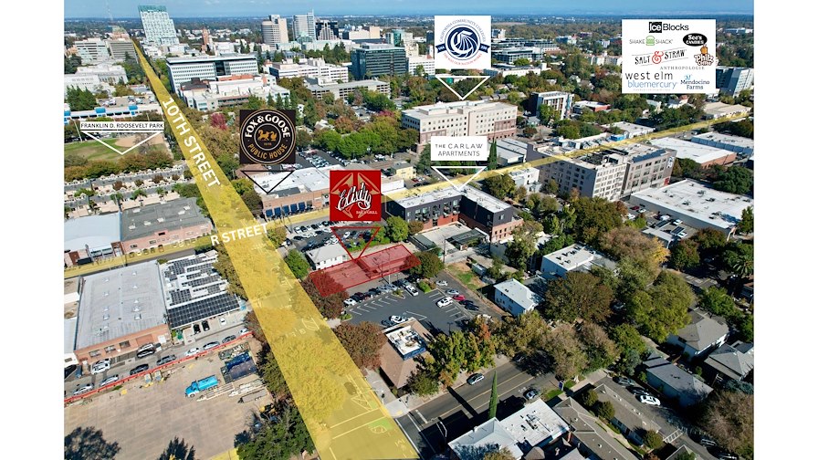
Elixir Bar & Grill in Sacramento R Street Corridor for Sale
A Sacramento Bar's Future is on the Table in a City Revitalization Gamble At the bustling corner of...

Phoenix Tailings to Open $375M Facility in Rochester
Phoenix Tailings is set to build a $375 million rare earth separation facility at Eastman Business Park in...