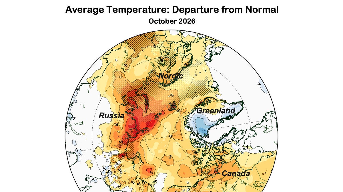
The Arctic ocean acted as a heating pad this October
The Arctic is warming faster than almost any other part of the planet, and October 2026 provided a stark illustration of why. According to data analyzed by Alaska Climate, more than 90 percent of the Arctic—covering both land and seas poleward of 60°N—experienced temperatures above the 1991-2020 baseline average. This warming trend is driven largely by a massive loss of sea ice, which fundamentally changes how the region handles heat as the sun begins to set for the winter.
In the Arctic, October is historically the fastest warming month of the year. This isn’t a coincidence; it is a direct consequence of disappearing ice. When sea ice is present, the air above it can cool to far below freezing. However, with much of the ice gone, the ocean surface—which cannot drop below roughly -1.8°C without turning to ice—effectively acts as a heating pad, pumping warmth directly into the atmosphere above it. This mechanism doesn’t just affect the water; it spills over onto the land, making October a period of intense thermal shift across the entire northern hemisphere.
Sea ice loss reaches striking levels in northern seas
The visual difference between the Arctic of the late 20th century and the Arctic of today is difficult to overstate. While the Chukchi and Greenland Seas maintained sea ice extents broadly similar to the 1979-2000 median, other regions looked unrecognizable. The northern Barents and all of the Kara Seas showed a striking lack of ice, and sizable patches of open water were visible in the Laptev and East Siberian Seas.

This lack of reflective ice cover contributes to a broader warming trend. This past October ranked as the third warmest October on record for the Arctic overall, trailing only 2020 and 2025. The frequency of these extreme months is increasing; all of the five warmest Octobers recorded since 1950 have occurred since 2018. For Arctic lands specifically, this was the fifth warmest October on record, with all five of the warmest instances occurring since 2020.
The implications of this shift extend far beyond local temperature readings. The relationship between sea ice and land temperature suggests that the ocean is becoming a primary driver of the Arctic’s seasonal climate, a role traditionally held by the atmosphere and snow cover. As the “heating pad” effect intensifies, the traditional seasonal transition from autumn to winter becomes increasingly blurred.
Alaska sees record snowfall and extreme precipitation shifts
While the Arctic as a whole saw its highest October precipitation since 1950—roughly 17 percent above the 1991-2020 baseline—the distribution of that moisture was incredibly uneven. In Alaska, temperatures were above normal virtually everywhere, ranking as the tenth warmest October since 1950. However, the way that warmth translated into precipitation created a landscape of extremes.
The state’s geography played a massive role in where the water fell. Mountains acted as physical barriers, creating dramatic contrasts in precipitation totals. The south side of the western and central Brooks Range saw very high totals, while the North Slope, located just across the range, experienced significantly below-normal precipitation. Similar patterns appeared in the Yukon Flats and the upper Tanana Valley.
Despite the widespread warmth, specific pockets of the state saw historic winter-like conditions. The upper Koyukuk valley experienced intense snowfall. Bettles reported 39.6 inches of snow, the highest on record since 1944, while Wiseman recorded 36.6 inches, the second highest since 1918. In other areas, such as Kotzebue and Nome, precipitation totals were among the highest in nearly a century and over a century, respectively.
| Location | October 2026 Metric | Historical Context |
|---|---|---|
| Bettles, AK | 39.6 inches of snow | Highest on record since 1944 |
| Wiseman, AK | 36.6 inches of snow | Second highest on record since 1918 |
| Kotzebue, AK | High precipitation | Second highest in ~95 years |
| Nome, AK | High precipitation | Third highest in 121 years |
For the state of Alaska as a whole, this was the seventh wettest October since 1950. This follows a consistent trend where, in five of the last six years, Alaska’s October precipitation has exceeded the 1991-2020 average. This increasing moisture, combined with higher-than-normal temperatures, is fundamentally altering the seasonal rhythm for Alaskan communities, from the North Slope to the Southeast.
As these patterns of warmth and moisture continue to deviate from historical norms, the question remains how much the Arctic climate system can shift before the traditional seasonal boundaries—and the ecosystems that rely on them—are permanently transformed.
Related reading

Manslaughter Suspect Arrested in Fatal Pearl Kai Robbery Case
Aiea robbery suspect in custody following fatal shopping center attack A 29-year-old man is in custody after a...

Wilmington Rental Market Becomes One of Nation’s Hottest Small Markets
Wilmington apartment demand defies North Carolina cooling trends While many small cities across North Carolina are seeing their...

UMass Boston Women’s Soccer Scores Goal in Match Against ECSU
UMass Boston and Eastern Connecticut State University faced off on November 7, 2026, in a competitive women’s soccer...

Vehicle Crashes Into Lakewood Massage studio causing structural damage
A vehicle crashed into the Renew Massage Studio in the Denver metro area early Saturday morning, causing significant...