Houston’s Streak of Perfect Weather Ends, Bringing Weekend Showers
Houston is basking in one more day of picture-perfect mid-autumn weather before a shift brings a chance of rain this weekend. The city is closing out the week with sunshine, mild temperatures, and low humidity, but forecasters are tracking an incoming system that could bring showers, and potentially some heavy downpours, to the area by Sunday. Space City Weather reported the change, noting that while Saturday looks to remain mostly dry, Sunday carries a higher likelihood of rain, especially south of the city.
The break in the weather is a welcome relief, with Thursday and Friday feeling like something out of a Nicholas Cage movie—refreshing and just right. But as we look toward the weekend, the forecast becomes a bit more complex. The culprit is an upper-level low-pressure system expected to park over Texas for several days, a pattern that will likely keep rain chances in the forecast for the start of next week as well. While this isn’t a washout for most of Houston, the potential for locally heavy rainfall south of the city has prompted a watchful eye from forecasters.
A Clear, Mild Friday Before the Weekend Shift
Today will be another delightful day across the Houston region. Expect plenty of sunshine, though some high clouds may stream into the area later in the afternoon. Highs will climb into the low 80s with that wonderfully low humidity we’ve enjoyed.
Friday will see the week close out with a mix of clouds and sun, though the overall feel will still be quite pleasant. Humidity will creep up just a bit, though likely not enough to be a noticeable change for most. Highs are expected to be in the upper 70s to near 80, following a slightly warmer start to the morning. While a shower can’t be entirely ruled out near Matagorda Bay, the vast majority of the region should remain dry.
The Weekend Forecast: From Dry to Damp
Saturday is shaping up to be a decent bet for a dry day, though it won’t be as sunny as the past few. We’ll start the morning mild, with lows in the upper 50s to around 60. Clouds will dominate the sky, though some sunny breaks are possible. A key feature of the day will be the wind direction—a northeast breeze that will help keep temperatures cooler, with highs only reaching the mid to upper 70s. Showers become a possibility later in the day, but only well south of Houston, toward Matagorda Bay and perhaps Brazoria County.
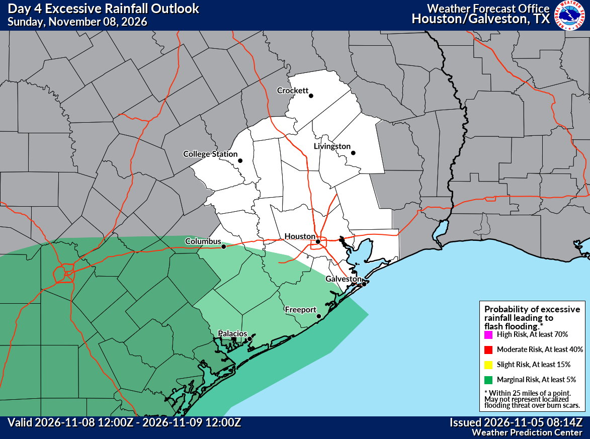
Sunday is the day when rain chances expand significantly into the Houston area. The forecast includes the potential for locally heavy downpours or some thunderstorms, particularly south of the city. The National Oceanic and Atmospheric Administration (NOAA) has highlighted a marginal risk for flash flooding (level 1 out of 4) for that region. “Sunday has washout potential south of Houston,” the forecast from Space City Weather noted. For the city and points north, the outlook is currently less severe, with expectations of passing showers or lighter rain and plenty of clouds. It’s important to remember that there’s still a good bit of uncertainty in this forecast, especially regarding the exact rainfall totals south of Houston. Temperatures should be noticeably cooler on Sunday, with highs only in the upper 60s.
The forecast shift for the weekend was first flagged by AI weather models, a tool the team at Space City Weather uses to complement traditional methods. As they explained, this type of “AI” isn’t like a chatbot; it’s machine learning that has been trained on years of historical weather data to learn the physics of the atmosphere. It can run much faster than traditional physical models, sometimes providing an extra day’s notice on a forecast change. The team emphasizes that they use these models not just because they are new, but because they add value and improve accuracy.
Early Next Week: Lingering Rain and Cooler Air
The weekend’s rain is courtesy of that stubborn upper low, which will linger over Texas into early next week. This means we may see continued chances for rain showers on Monday and Tuesday. Neither day is expected to be a complete washout, but residents should plan on at least some rain and persistent clouds. More notably, some cooler air is expected to get dragged into the area as well. This will lead to lows in the lower 50s, with some areas possibly dipping into the upper 40s, and highs in the low 70s or even upper 60s if clouds hang around.
Looking further ahead, the middle of next week is expected to bring a couple of nicer days before another chance of rain returns toward the following weekend. Temperatures should rebound into the mid to upper 70s, with lows in the 50s. For now, the focus is on the approaching weekend, where the primary concern is the potential for heavy rainfall south of a line from Houston to Matagorda Bay, a area that has seen its share of flooding challenges in the past. The forecast will likely be refined over the next couple of days, so staying updated will be key for anyone with weekend plans.
Worth a look
SEIU Emerges as Rhode Island’s Most Powerful Union After Election Sweep
There’s a new sheriff in town in Rhode Island labor politics, and his name isn’t a union at...

Columbus company Pursuit made Amy Acton’s victory speech suit
Ohio Gov.-elect Amy Acton wore a white suit from a Columbus-based company for her victory speech. The suit...

Millbrook Townhomes Offer Smart Living in Salem Utah
Millbrook Townhomes Hit Salem Market as Viridian Community Expands D.R. Horton has unveiled the Millbrook, a new two-story...

North Dakota farmer Ralph Steenson died in 2002 plane crash
A North Dakota Farmer's Final Flight "He had a great zest for life," Brenda Steenson said of her...