Maine is currently navigating a significant, if uneven, hydrological event.
According to data provided by WMTW, preliminary rainfall totals across the state reveal that some regions have received a soaking, while others remain relatively dry. The distribution of this precipitation highlights a notable geographic divide, with coastal and central counties recording substantially higher accumulation than those in the northern and western reaches of the state.
For residents and local industries, the impact of this rainfall is immediate. While farmers and municipal water managers generally welcome the moisture to replenish soil saturation and local reservoirs, the variance in intensity means the relief is not distributed equally. The figures, reported by the National Weather Service in Gray, serve as a precise map of where the current weather system has exerted the most influence.
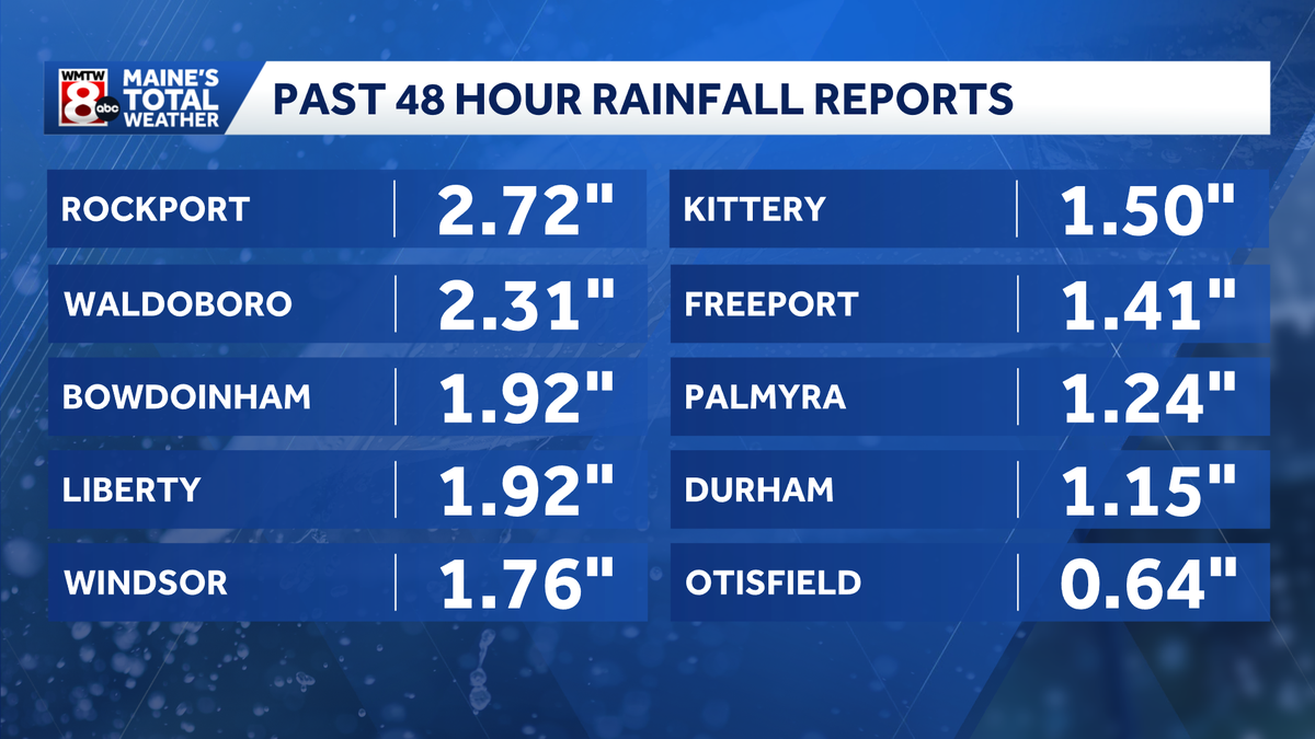
The following table outlines the reported rainfall across several Maine counties, illustrating the wide range of accumulation reported thus far:
| County | Town | Amount (inches) |
|---|---|---|
| Knox | Rockport | 2.72 |
| Lincoln | Waldoboro | 2.31 |
| Sagadahoc | Bowdoinham | 1.92 |
| Waldo | Liberty | 1.92 |
| Kennebec | Windsor | 1.76 |
| Cumberland | Freeport | 1.41 |
| York | Kittery Point | 1.50 |
| Androscoggin | Durham | 1.15 |
| Somerset | Palmyra | 1.24 |
| Franklin | Kingfield | 0.45 |
| Oxford | Otisfield | 0.64 |
The “so what” of this weather event lies in the state’s reliance on seasonal precipitation cycles. For the agricultural sector, particularly in counties like Kennebec and Knox, these totals represent a vital late-season infusion.
However, for communities in Franklin or Oxford County, where totals have remained significantly lower—with some areas in Franklin County reporting less than 0.10 inches—the lack of substantial rain may prolong existing dry conditions. This disparity creates a patchwork of risk for local fire safety protocols and groundwater management, which are often governed by the Maine Forest Service and local water districts.
While the numbers provide a clear snapshot, they also show the limitations of voluntary reporting. The National Weather Service notes that if a specific town does not appear in the current data, it is because no official reports were filed from that location. This creates a data gap that can mask the reality of conditions in more rural or less densely populated townships.
The situation in the neighboring regions of New Hampshire follows a similar pattern of relative scarcity. In Coos County, for instance, reports from Berlin and Mount Washington show minimal accumulation—0.18 and 0.09 inches respectively—suggesting that the moisture-heavy system was largely concentrated in the central and coastal regions of Maine rather than pushing deep into the northern mountains.
As the state monitors these figures, the practical concern for many remains the long-term impact on the water table. The United States Geological Survey consistently tracks these fluctuations to determine the broader health of regional aquifers. While the current totals are beneficial, they do not necessarily offset the cumulative deficit that can build up during drier months of the year.
The variability in these rainfall totals shows how localized New England weather is. One town may see enough rain to saturate the topsoil, while a neighbor just a few miles away sees barely enough to dampen the pavement. This reality continues to shape how Maine manages its natural resources and infrastructure, balancing the immediate benefits of the rain against the broader, ongoing requirements of the state’s diverse climate zones.
Worth a look

WPI Wrestling Places 17 at Rhode Island College Invitational
WPI wrestling finished second at the Rhode Island College Invitational and Schwartz Report New England Showdown this past...

College GameDay Heading to Boise State for Oregon State Matchup
Boise State’s Path to the Playoff For the first time since 2010, the iconic blue turf of Albertsons...

Oklahoma Upsets Florida: Jason Witten and John Mateer Lead Sooners to Victory at The Swamp
Oklahoma secured a 23-7 victory over the No. 24-ranked Florida Gators at Ben Hill Griffin Stadium on Saturday...
John Krist: North Dakota’s Badlands Shaped Theodore Roosevelt’s Legacy
The Lakota Sioux called it mako shika. French fur trappers, navigating the upper reaches of the Missouri River,...