
A slow-moving storm pushed rain across the northern Wasatch Front and Tooele County on Tuesday, with cold air behind the front set to drop snow to valley floors overnight, KUTV reported.
The precipitation began early in western Utah and spread east along the Interstate 15 corridor through the morning and early afternoon, bringing pockets of moderate rain before a brief lull during the evening commute.
Forecasters expect a second band of moisture to arrive later Tuesday night as temperatures fall, allowing snow to reach the benches and valley floors, though warm ground temperatures should keep most accumulation on grassy areas, elevated surfaces, and vehicles.
“Grab the umbrellas! After a mild start in the morning, a strong cold front will cross the state, bringing widespread valley rain & mountain snow and much cooler temperatures,” the Fox 13 Now weather team wrote in its morning forecast discussion.
South winds ahead of the front gusted above 45 mph between 10 a.m. and 10 p.m., according to Fox 13 Now, adding a wind chill to the dropping temperatures. In the mountains above 8,000 feet, the storm is expected to drop four to ten inches of snow, with one to four inches along the Wasatch Back and a dusting possible on the northern Utah benches by evening.
High temperatures Tuesday struggled to the mid-50s along the Wasatch Front before plummeting near 30 degrees overnight. In St. George, rain showers and a slight chance of morning thunderstorms gave way to partial clearing, with highs in the upper 50s and overnight lows in the upper 30s.
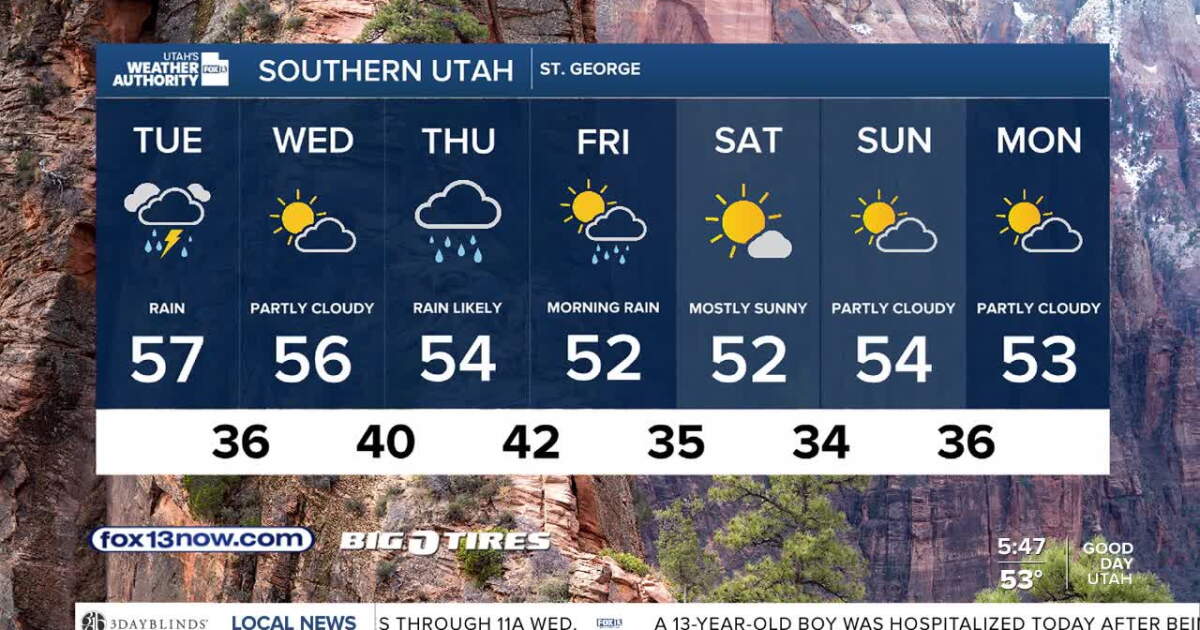
The system exits overnight Wednesday, leaving a dry break before the next, more potent storm takes aim at the state Thursday through Friday. That system arrives as rain Thursday but transitions to a rain-snow mix as colder air filters in, with precipitation potentially changing to all snow by Friday evening as the low pulls away.
The weekend looks dry, but the active pattern continues. Another storm is on track to bring rain and snow back to Utah on Monday, and a fourth system may clip the state around the middle of next week.
Keep reading

NerdWallet: 70% of Canadian Parents Anxious Over Holiday Spending
Canadian parents are heading into the holiday season with a 70% anxiety rate over spending, driven by pressure...

April Hadley Johnson Dies at 81 in Laramie, Celebration of Life Dec. 12
April Hadley Johnson died November 11 at 81 in Laramie, with a celebration of life scheduled December 12...

Milwaukee Bucks and Jack Daniel’s Announce Third Single Barrel Collection with First Barrel-Proof Expression
The Milwaukee Bucks and Jack Daniel's announced their third Single Barrel Select collection on Monday, a release distinguished...

More Than 70 WV Guard Members Clean Kanawha Boulevard Sunday to Honor Beckstrom, Wolfe
More than 70 West Virginia National Guard members spent Sunday cleaning Charleston’s Kanawha Boulevard to honor Sarah Beckstrom...