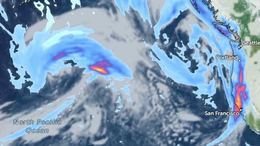
Up to four inches of rain and 60 mph coastal gusts are bearing down on western Washington as a strengthening Pacific storm fed by former typhoon Cempaka sweeps onshore.
The Pacific weather system began gearing up hundreds of miles off the coast on Friday morning, bringing characteristics of an atmospheric river that make it stronger and wetter than a typical fall disturbance, KIRO Newsradio meteorologist Ted Buehner reported.
The moisture driving this weekend’s weather originates from former typhoon Cempaka, which recently moved northeast into the North Pacific and embedded itself into the evolving system. Rain will reach the outer coast on Saturday afternoon before spreading across western Washington by Saturday evening and clearing into eastern Washington by Sunday morning.
Along the coast, up to two inches of rain is expected. Higher elevations in the Olympics and Cascades face up to four inches of rainfall with elevated snow levels near 5,000 feet, while the rest of western Washington will see totals ranging from a half inch to just over an inch.
Wind impacts will accompany the moisture. Peak wind gusts are forecast to reach 60 mph along the coast on Saturday night. From Everett northward in the North Sound, winds are expected to run 25 to 40 mph with gusts up to 50 mph, while elsewhere across western Washington, southerly winds will range from 20 to 30 mph with gusts up to 40 mph.
Those conditions could trigger local power outages. Coastal waves may reach 25 feet with rapid beach run-up and sneaker waves carrying logs and other debris, prompting warnings for storm watchers to stay on higher ground and avoid jetties.
Public works authorities are asking residents to keep storm drains clear of fallen leaves to prevent roadway ponding from rain runoff, particularly since Saturday’s highest high tide in Seattle, Olympia, and Everett occurs in the morning around 9 a.m. and will miss the strongest overnight winds.
Mild mid-November weather with highs in the mid-50s to lower 60s will persist through Saturday before yielding to post-system showers and cooler 50-degree highs on Sunday. Showers will linger on Monday as mountain snow levels drop to near 4,000 feet, bringing snow to Stevens and White Passes but missing Snoqualmie Pass.
Despite the soggy forecast, western Washington rivers remain well within their banks following a dry October and early November, with the exception of the Skokomish River in Mason County. Although weekend rains will raise river levels, no major flooding is expected next week, though residents can monitor updates on the National Weather Service website.
Phoenix Areas of Rain Expected to End Saturday Evening
Phoenix areas of rain expected to end Saturday evening across the Valley after a brief weekend storm system...

Spartans to Face Alabama State on Sunday Night at Home – SJSU Athletics
The San José State men's basketball team will host Alabama State on Sunday, November 15, at 6 p.m....

Drone Attacks on Power Stations Plunge Sudan’s Cities Into Darkness
Sudan faces a severe energy crisis as a wave of targeted drone strikes drives down electricity generation and...

Author Questions Colleague Taking Four Days’ Leave to Play World of Warcraft
In a column for Region Canberra, the publication reported that a worker took four days of annual leave...