Houston’s Dramatic Cooldown Arrives as Temperatures Plunge 12 to 20 Degrees After Record Heat
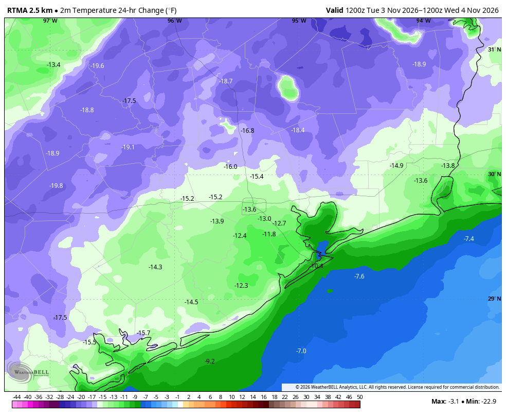
Houston woke up to significantly cooler temperatures on Wednesday morning. Sunrise temperatures across the region tumbled into the 50s, marking a drop of 12 to 20 degrees compared to just 24 hours earlier. The change is so stark that residents stepping outside likely felt as though they had been transported straight into mid-November, with November-like conditions now expected to persist for the foreseeable future across Southeast Texas.
Weather Bell reported that a sustained pattern change has officially taken hold, triggered by a cold front that swept through the area on Tuesday right on schedule. The front delivered much-needed rainfall to a region still grappling with drought conditions, though the relief was unevenly distributed. While a solid portion of the Houston area picked up at least 0.5 inches of rain, some locations saw totals reach 1 inch or more. The drought is far from over, but these showers—and potentially more in the coming days—should carry the region through until winter arrives and the expected El Niño pattern brings wetter conditions overall.
Tuesday’s high reached 88 degrees, tying a record high for the date and making for an incredibly sultry, muggy early November day. Much of that oppressive heat was due to abundant sunshine, but also to a meteorological phenomenon known as compressional heating, where the advancing front compressed and heated the air ahead of it as it pushed into the Houston area. Now that the front has passed, that stifling air mass is gone.
Record Heat Gives Way to Crisp Autumn Air
The contrast between Tuesday and Wednesday could not be more pronounced. Highs are expected to reach the mid-70s under sunny skies with low humidity, while overnight lows will drop into the 50s.
Looking ahead to Thursday and Friday, the onshore flow resumes early Thursday, allowing temperatures to climb back into the upper 70s with a return of slightly higher humidity. Skies should remain mostly sunny. Another front is forecast to push through Thursday night, carrying a slight chance of rain as it moves into the Houston area, though meteorologists note there simply is not much moisture in the atmosphere to work with. By Friday, modestly drier air should settle in, with highs again in the upper 70s and overnight lows around 60 degrees in the city, while outlying areas will see cooler conditions.
Forecast Shifts for Weekend Temperatures
The biggest question mark on the forecast involves the weekend, where humidity levels will continue to fall but precipitation chances remain difficult to pin down. Saturday looks promising with highs in the lower 70s and a mere 10 percent chance of rain. Sunday, however, carries a 40 percent chance of showers as a potential low-pressure system may pass nearby. While most computer modeling keeps the system far from the coast, some AI guidance suggests it could move closer to Southeast Texas. Highs Sunday should max out in the 60s, with overnight lows falling into the 50s.
Perhaps the most significant development arrives Sunday and Monday nights, which are expected to bring some of the coldest temperatures of the season so far. Much of Houston will see lows near 50 degrees, while areas further inland are likely to dip into the 40s. After this cold snap, a slow warming trend should begin next week, though the pleasant 70s-for-highs and 50s-for-lows pattern will likely hold through at least Thursday or Friday. There is also a possibility that rain chances improve later next week, but the forecast remains uncertain on that front.
The extreme temperature drop also highlights an earlier contest prediction from March, when Houston’s last cold night of the season saw temperatures drop to 33 degrees. At that time, Weather Bell asked readers to predict when the city might see 33 degrees again. While the mercury has not come close to that mark yet, and no such cold is expected in the next two weeks, the contest remains open and under close watch as the region moves deeper into fall.
After a record-hot, humid Tuesday that felt more like August than November, Houston is finally getting a true taste of autumn. The cooler, drier air mass settling over the region this week offers a preview of the winter pattern to come, even if the weekend rain forecast remains stubbornly difficult to predict.
Worth a look

SWAT Team Arrests Cheyenne Man Following Felony Strangulation Warrant
When the flash-bang detonated outside the house at 8512 Cowboy Road just after 8 a.m. Wednesday, the sound...
39 Best Art Galleries and Museums in Downtown Charleston: An Interactive Guide
Thirty-nine galleries and museums now anchor downtown Charleston's cultural landscape, stretching from the French Quarter down to Gallery...
UW-Madison Campus Features Autumn Colors and Wildlife
Four sandhill cranes were photographed frolicking near Rennebohm Hall and the Nielsen Tennis Stadium during an autumn evening,...

Olympia Community Solar and Grace Episcopal Church Launch 73-Panel Solar Project on Bainbridge Island
"Grace Episcopal Church is honored to join the solar energy community in Kitsap County," said Eric Mason. "Caring...