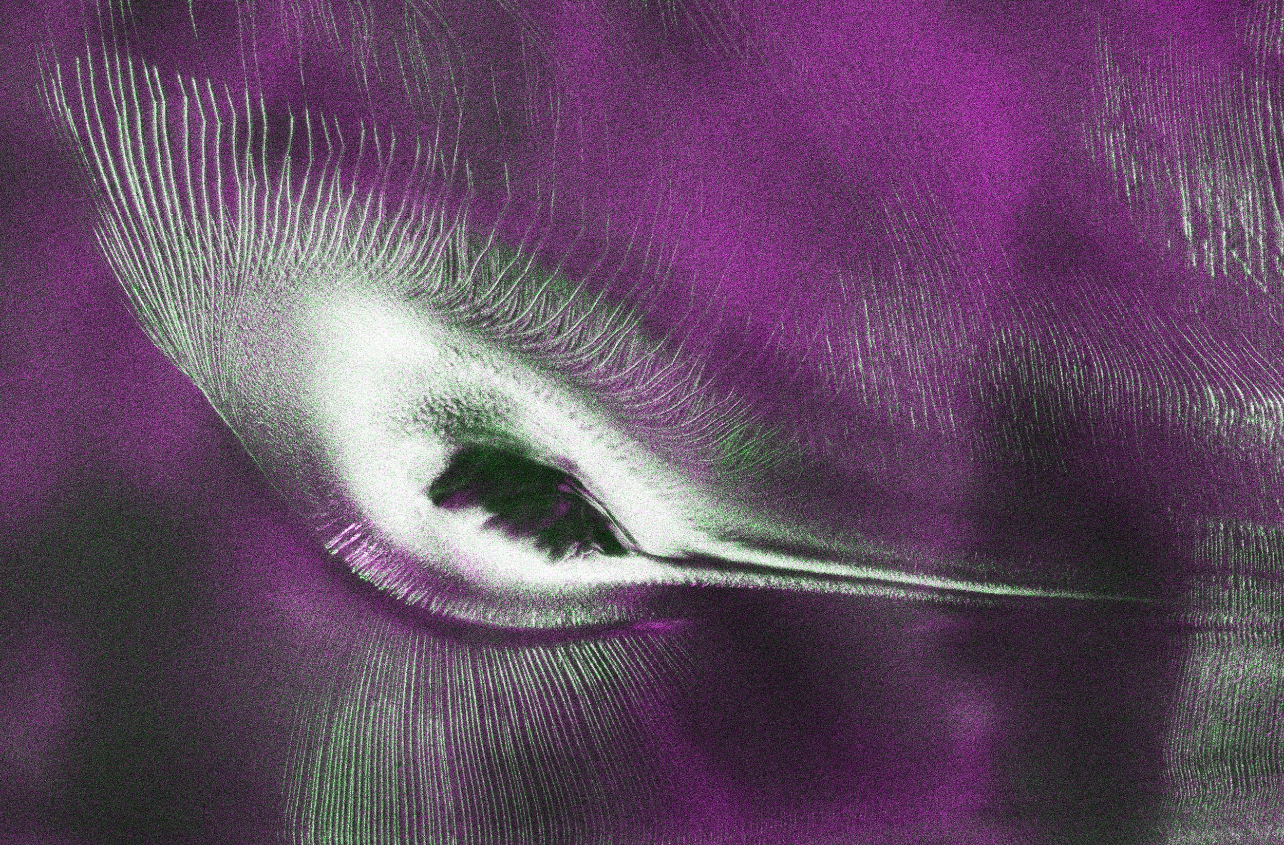
As of July 20, 2026, the public can freely access data from the NASA-ISRO Synthetic Aperture Radar satellite. Launched from India on July 30, 2025, the joint Earth-observation mission has captured detailed radar imagery, including a striking East Antarctic ice formation nicknamed the hummingbird.
NASA-ISRO Satellite Opens Data Access Through Bhoonidhi and U.S. Portals
The public launch of information from the NASA-ISRO Synthetic Aperture Radar satellite marks a major milestone for international space cooperation. Following nearly a year of instrument calibration and system testing, data from both of the spacecraft’s radar systems is now streaming to researchers and mission teams in the United States and India who will release files processed from the satellite’s L-band and S-band radars on an ongoing basis. As of July 20, the public can access data from the two powerful radar instruments aboard the NISAR (NASA-ISRO Synthetic Aperture Radar) satellite.
Teams in the United States and India will release files processed from the satellite’s L-band and S-band radars on an ongoing basis, helping researchers and other users track the movement of Earth’s land and ice masses, monitor changes in ecosystems like forests and wetlands, and respond to natural hazards such as landslides and earthquakes. The release comes as NASA and ISRO (Indian Space Research Organisation) prepare to celebrate the first anniversary of NISAR’s July 30, 2025, launch from India’s Satish Dhawan Space Centre. Since that time, the mission engineering and science teams have been busy calibrating instrumentation, refining algorithms, and monitoring nearly all the planet’s land- and ice-covered surfaces twice every 12 days. Along the way, the team has captured scenes from around the globe — urban street grids, agricultural fields, landslides, earthquakes, and sinking land in Mexico City. Earlier on September 25, 2025, NASA-Jet Propulsion Laboratory (JPL) had shared the first set of images taken using the L-Band SAR within 90 days of the launch of mission, the scheduled time for the full-science operation term to commence. The joint mission of NASA-JPL and ISRO was launched on July 30, 2025, using the GSLV-F16 from Satish Dhawan Space Centre in Sriharikotta. While NASA will receive 35 tetrabyte, the National Remote Sensing Centre will receive 8-tetrabyte data and the Antarctica Centre will also receive data. Isro has made public the first batch of S-Band radar data from the Nasa-Isro Synthetic Aperture Radar (SAR) or Nisar mission, releasing it through Bhoonidhi, the agency’s earth observation data portal.
The joint mission was launched on July 30, 2025, utilizing a GSLV-F16 from Satish Dhawan Space Centre in Sriharikota. Operating at an orbital altitude of 747 kilometers, the spacecraft revisits the same spot every 12 days, having surveyed nearly every land and ice-covered part of Earth twice every 12 days. The mission employs a 12-metre reflector antenna and a scanning technique called SweepSAR, which lets it capture a wide strip of the Earth’s surface, about 240 km across, in high resolution without sacrificing coverage.
The Story Behind the Antarctic ‘Hummingbird’ Ice Formation
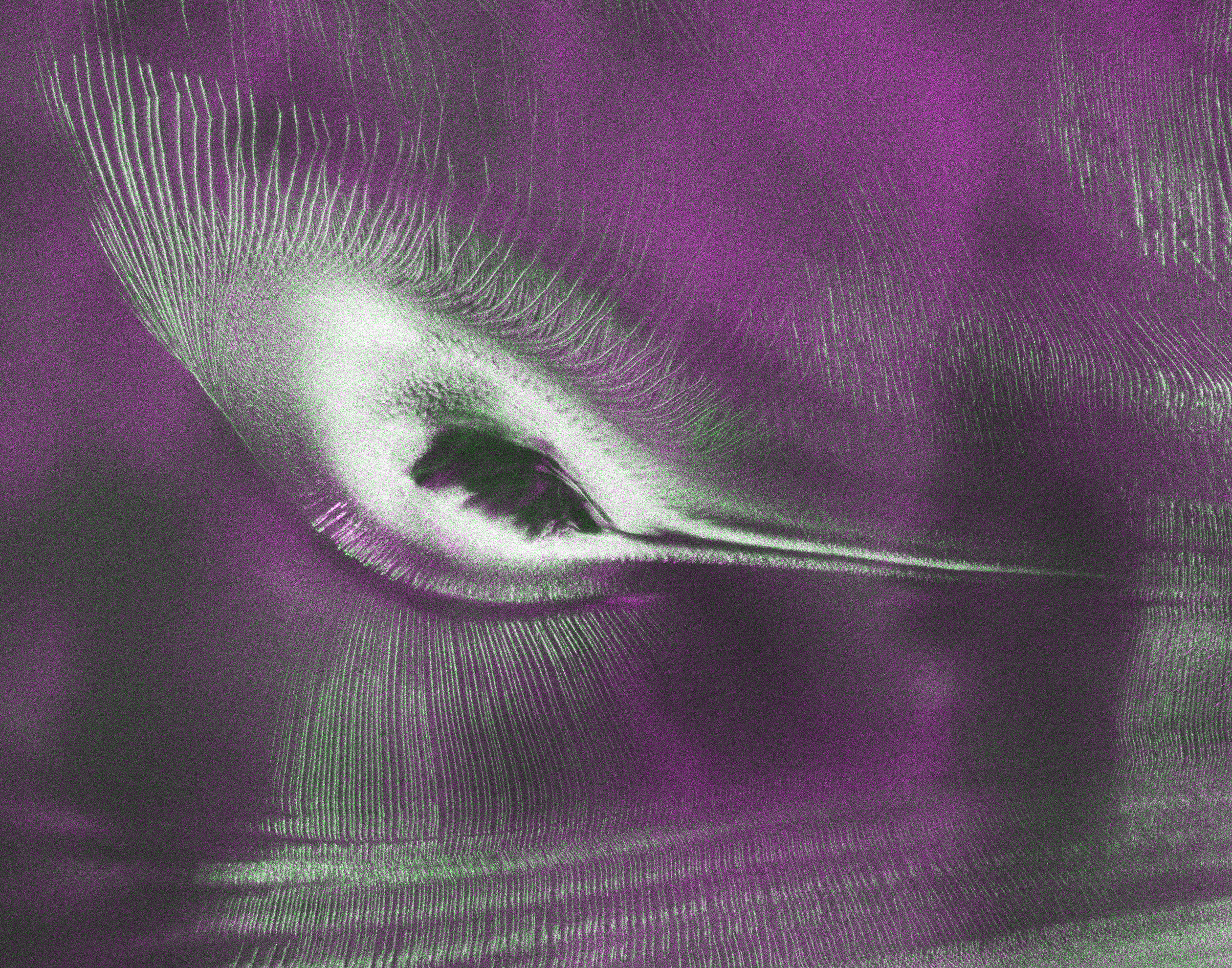
Among the early images released from the mission is a view of East Antarctica that has captivated scientists and the public. Captured using L-band radar measurements gathered in August 2025, the image depicts Nunatak Zaterjavshijsja, a rocky mountaintop protruding through the vast ice sheet. The NISAR satellite captured deep cracks, known as crevasses, in the glacier ice surrounding the Nunatak Zaterjavshijsja mountaintop in East Antarctica. The NASA-ISRO Synthetic Aperture Radar (NISAR) satellite, a joint mission by the United States’ (US) NASA and India’s ISRO, has released a striking radar image of Antarctica that bears a strange resemblance to a hummingbird, delighting scientists and the public alike. The picture, created using data from NISAR’s L-band radar, shows Nunatak Zaterjavshijsja, a mountain peak in East Antarctica situated within a northeast-flowing ice stream.
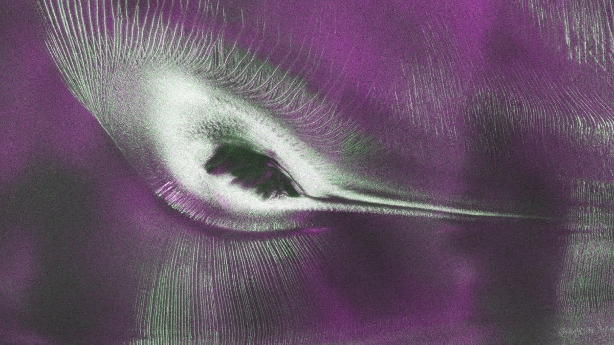
In East Antarctica, the moving ice collides with the mountain peak, which builds up pressure that causes deep cracks, known as crevasses, to form on the surface. These cracks appear as sharp green lines resembling a bird’s wings, prompting scientists to nickname the formation ‘Hummingbird’. The data was collected in August 2025 while mission teams were testing the satellite’s systems, and has now been made public as NISAR approaches its first year in orbit. Nicknamed the hummingbird
by Nisar scientists, the striking formation is not a real animal but a remarkable combination of mountain, ice and radar technology revealing hidden details of Earth’s icy continent. As glaciers flow northeast toward the ocean, the exposed mountain acts as an obstacle, placing enormous stress on the moving ice around it.
While standard optical photographs of the region display an almost uniformly white landscape with faint shadows, the radar data uncovers structural details hidden beneath the surface. The vibrant colors in the image reflect how microwave signals interact with the terrain.
Decoding Radar Backscatter and Dual-Frequency Capabilities
The satellite relies on active microwave transmission rather than sunlight, allowing it to collect data through darkness, cloud cover, and heavy weather. Unlike conventional satellites that rely on sunlight, Nisar sends polarised microwave radar waves toward Earth and analyses how they bounce back. Radar satellites work differently from ordinary cameras. Instead of relying on sunlight, they send microwave signals toward Earth and measure the reflections that come back. That means they can collect information day or night and, in many situations, see through clouds. Some radar wavelengths can even penetrate snow, ice, or dense tree cover to reveal details that optical images cannot.
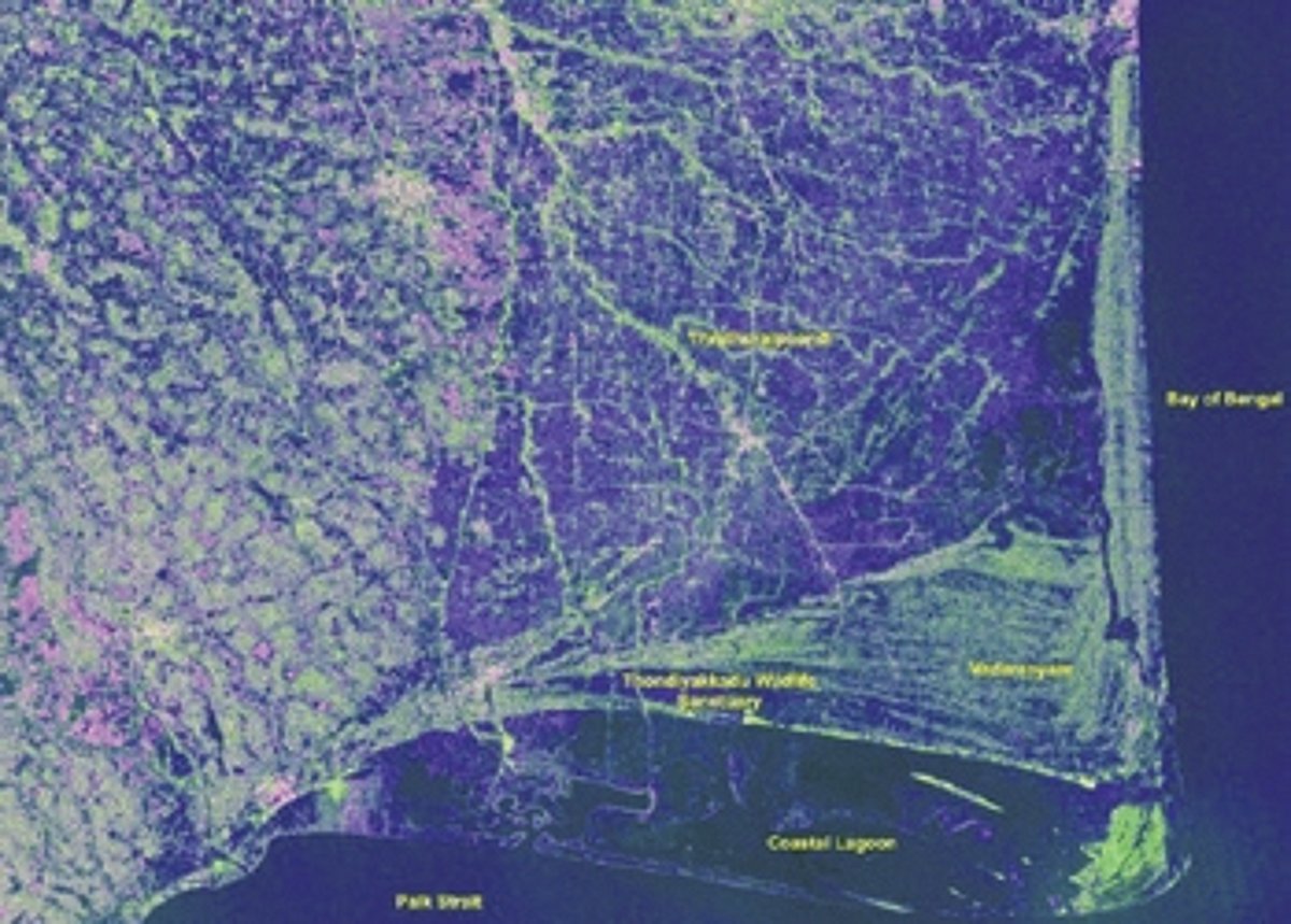
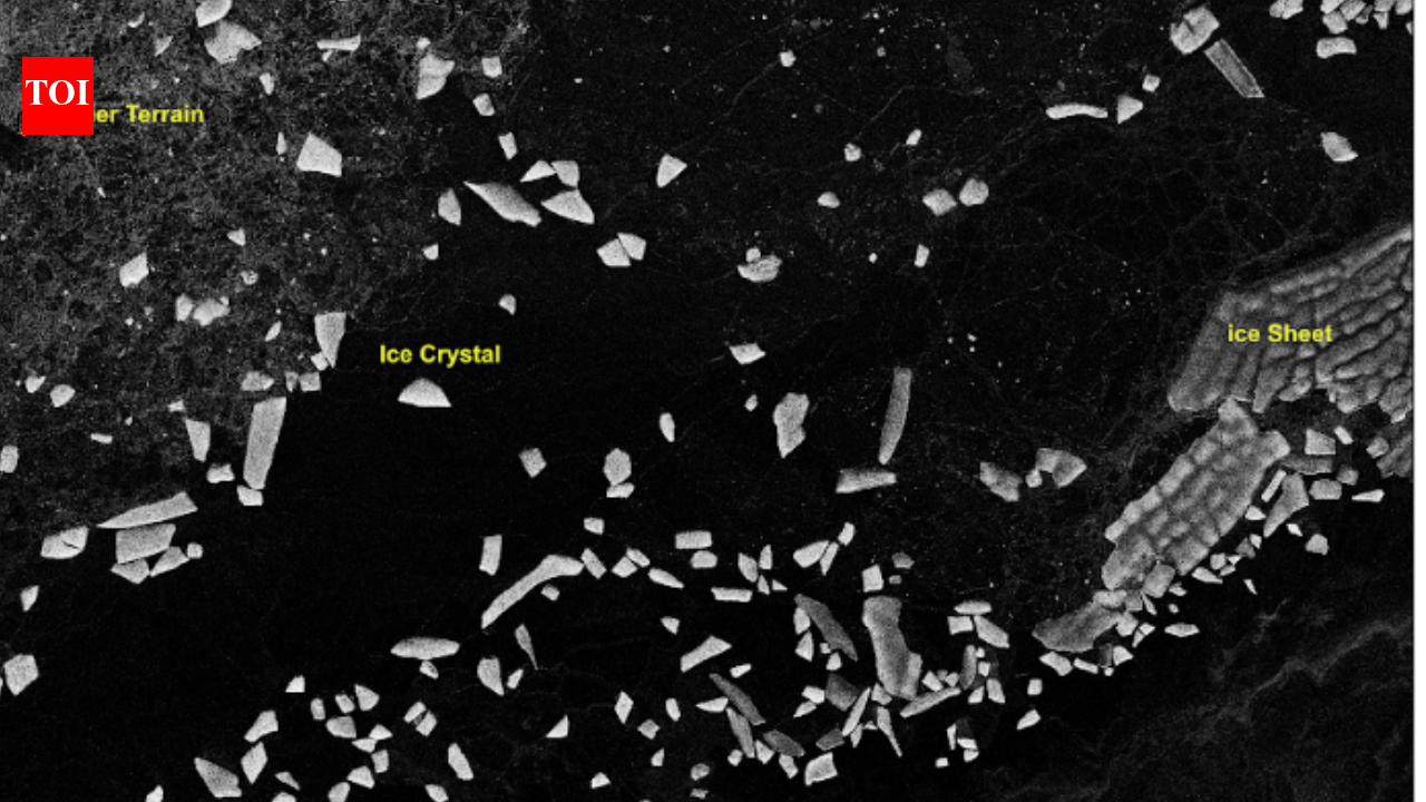
Nisar is a joint mission between Nasa and Isro, and is the first spaceborne radar to carry two frequency bands, L-band and S-band, on a single satellite. The longer L-band wavelength penetrates tree canopies to monitor underlying terrain, while the S-band effectively evaluates canopy structures. Together, the instruments provide comprehensive monitoring capabilities for glaciers, forests, wetlands, and natural hazards including earthquakes and landslides. The agency also shared sample images from Tamil Nadu (Nagapattinam), Antarctica, Assam (Brahmaputra basin), Idaho, Greenland and Indonesia showing the radar’s range of applications, from tracking coastal wetlands to mapping irrigation patterns and ice movement, underlining the mission’s relevance to both scientific research and everyday resource management, from coastal planning to precision farming and disaster monitoring.
Active Observation Schedules and Future Data Expansion
The mission has officially entered its active science phase. Earth is always changing. Glaciers move, forests grow and shrink, wetlands shift, and the ground itself can rise or sink after earthquakes. Watching those changes from space helps scientists understand what is happening and respond faster when nature takes an unexpected turn. Now, anyone can explore data from one of the most capable radar satellites ever launched. As of July 20, 2026, the public can access information collected by the NASA-ISRO Synthetic Aperture Radar, better known as NISAR. The mission’s two radar systems are designed to monitor Earth’s land and ice in remarkable detail, giving researchers powerful new tools to study the planet over time.
Related reading

SpaceX Launches Final Three O3b mPOWER Satellites for SES
SpaceX successfully launched the final three O3b mPOWER satellites for SES on September 13, 2026, from Cape Canaveral...
Japan Launches Kaguya Spacecraft to Map Moon in 2007
On September 13, 2007, Japan launched its advanced Kaguya spacecraft from the Tanegashima Space Centre aboard an H-IIA...

Astronomers Identify Eos, a Massive Molecular-Hydrogen Cloud Near the Sun
Astronomers have identified Eos, a massive molecular-hydrogen cloud located roughly 300 light-years away and spanning 40 full-Moon widths...
Researchers Find Diamond Melting Point Is Lower Than Previously Measured
Researchers zapping synthetic diamond plates with a powerful ultraviolet laser discovered the mineral's melting point is more than...