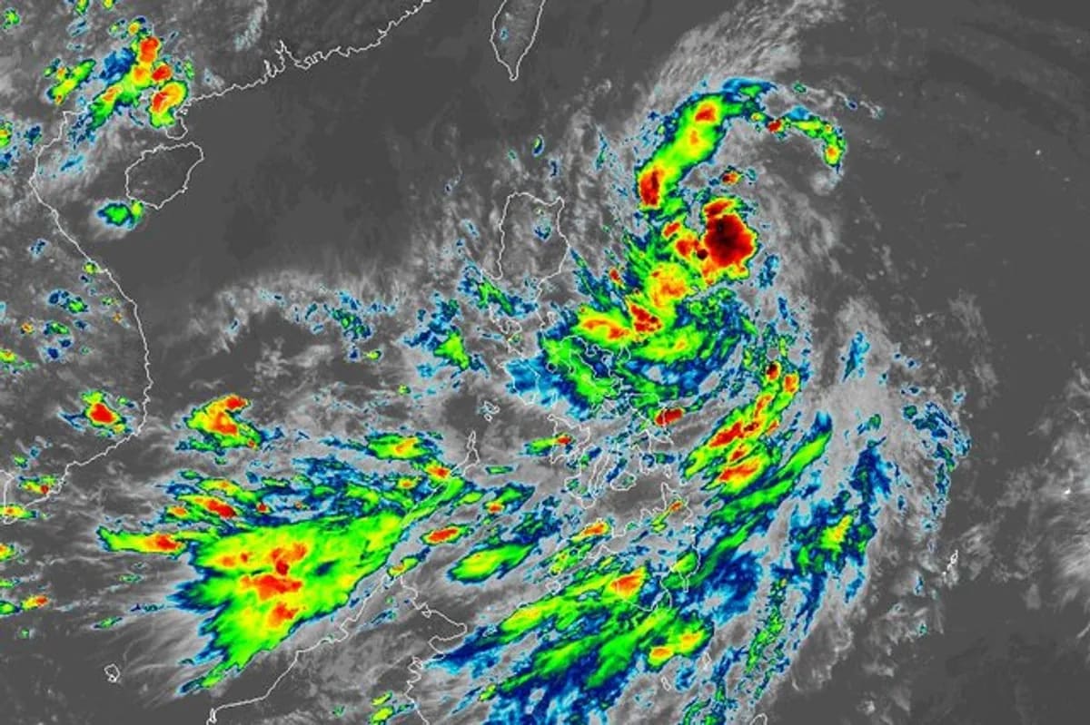
As Tropical Storm Kiyapo intensified into a typhoon and exited the Philippine area of responsibility early Saturday, Tropical Cyclone Wind Signal No. 1 remained hoisted over Batanes, parts of the Babuyan Islands, mainland Cagayan, northern Apayao, and Ilocos Norte, bringing continued heavy rain, flood risks, and suspended travel across multiple regions.
Typhoon Intensification and Exit from the Philippine Area of Responsibility
Tropical Storm Kiyapo, carrying the international name Noul, rapidly strengthened as it moved away from the Babuyan Islands, intensifying into a typhoon shortly before leaving the Philippine area of responsibility early Saturday morning. By 4 a.m. on Saturday, state meteorologists located the center of the storm 320 kilometers west of Basco, Batanes, packing maximum sustained winds of 120 kilometers per hour with gustiness reaching up to 150 kph.
Prior to its exit, the storm battered large parts of Luzon, the Visayas, and Mindanao. Friday afternoon operations tracked the system near Calayan Island, where it generated maximum sustained winds of 85 kph and gusts up to 115 kph while moving west-northwest at 30 kph, according to disaster management reports. Even though the core of the typhoon crossed out of national waters, the state weather bureau confirmed that Kiyapo
is forecast to move generally northwestward toward mainland China through Sunday before turning north-northwestward and weakening rapidly inland.
Lingering Wind Signals and Heavy Rainfall Warnings Across Luzon and Visayas
Even with the system positioned outside national jurisdiction, local weather authorities maintained Tropical Cyclone Wind Signal No. 1 over Batanes, the western portion of the Babuyan Islands including Calayan, Dalupiri, and Fuga islands, the northwestern portion of mainland Cagayan covering Pamplona, Sanchez-Mira, Claveria, and Santa Praxedes, the northern portion of Apayao encompassing Luna and Calanasan, and the province of Ilocos Norte.
The combined effects of the typhoon and the enhanced southwest monsoon, locally known as habagat, continued to threaten western sections of Luzon and the Visayas with heavy precipitation. Forecasters issued orange and yellow rainfall warnings across southern Negros Occidental, southwestern Negros Oriental, northern Ilocos Sur, central and northern Zambales, and Bataan, warning residents that flooding and landslides remain possible in saturated low-lying and mountainous zones.
Widespread Floods, Class Suspensions, and Emergency Rescues
The storm’s initial onslaught triggered severe disruptions nationwide. In Cagayan, authorities suspended in-person classes across 24 municipalities and Tuguegarao City while preemptively evacuating 95 residents from 21 families in Santa Ana, Lal-lo, and Gonzaga, alongside enacting local liquor bans. Mountain roads in the Cordillera saw traffic reduced to single lanes due to road slips in Calanasan, Apayao, and damaged bridge girders along the Pico-Lamtang Road in Benguet, the Department of Public Works and Highways reported.
Further south, floodwaters submerged 40 of Iloilo City’s 180 barangays under knee- to waist-deep water, while the Philippine Coast Guard deployed rescue teams to assist residents stranded in Antique and Guimaras. In General Santos City, about 500 families faced displacement after flash floods inundated low-lying communities when the Makar River swelled following persistent downpours. Across all affected sectors, local disaster response agencies confirmed that no deaths or injuries were reported despite extensive infrastructure and property damage.
Keep reading
Canada Seeks Unique EU Alliance Amid US Trade War
Canadian Prime Minister Mark Carney addressed reporters in Toronto on Sunday, outlining a new diplomatic and economic direction...

Israeli Attacks in Gaza Kill Pregnant Woman and 10 Others
A pregnant Palestinian woman was shot and killed by Israeli forces in southern Gaza as artillery shelling and...

Iran and Gulf Nations Postpone Oman Talks Over Regional Consensus
The delay comes as oil prices fluctuate, U.S. economic sanctions expand, and military tensions in the region escalate...
After Louvre Heist, Robberies Continue at French Museums
Following a dramatic daytime heist at the Louvre, a string of break-ins has struck museums and churches across...